Record warmth continues, Rafael expected to struggle after entering Gulf of Mexico
Scattered showers and thunderstorms will lessen for the remainder of an unseasonably warm and humid week. Rafael is expected to enter the Gulf of Mexico as a hurricane later this week, but its future remains challenged and unclear.
Scroll down to The Tropics section for the latest on Tropical Storm Rafael.
Tonight & Tomorrow: Overnight, a weak cold front will start to fall apart west of the Capital Area leaving warm and muggy conditions in place. Lows will stay in the low to mid 70s beneath mostly cloudy skies. Rain coverage will be much more scarce on Wednesday since the cold front will be less defined and farther west. A mix of sun and clouds is expected. Highs will climb into the upper 80s.
Up Next: Thursday and Friday will be partly cloudy, warm and muggy with highs in the upper 80s and lows in the low 70s. Either day, rain coverage will be on the low end, with little more than twenty percent of the area seeing any showers.
Into the weekend, the weather will hinge on the eventual evolution of Rafael. Based on a weakening tropical system, the Storm Station 7-Day Forecast shows the same warm and muggy conditions with mostly cloudy skies and only spotty showers. Of course, given a tropical system in the region there may be a breeze and some minor coastal flooding as well. However, the forecast is closely tied the intensity and track of this system. That remains difficult to pin down.

Trending News
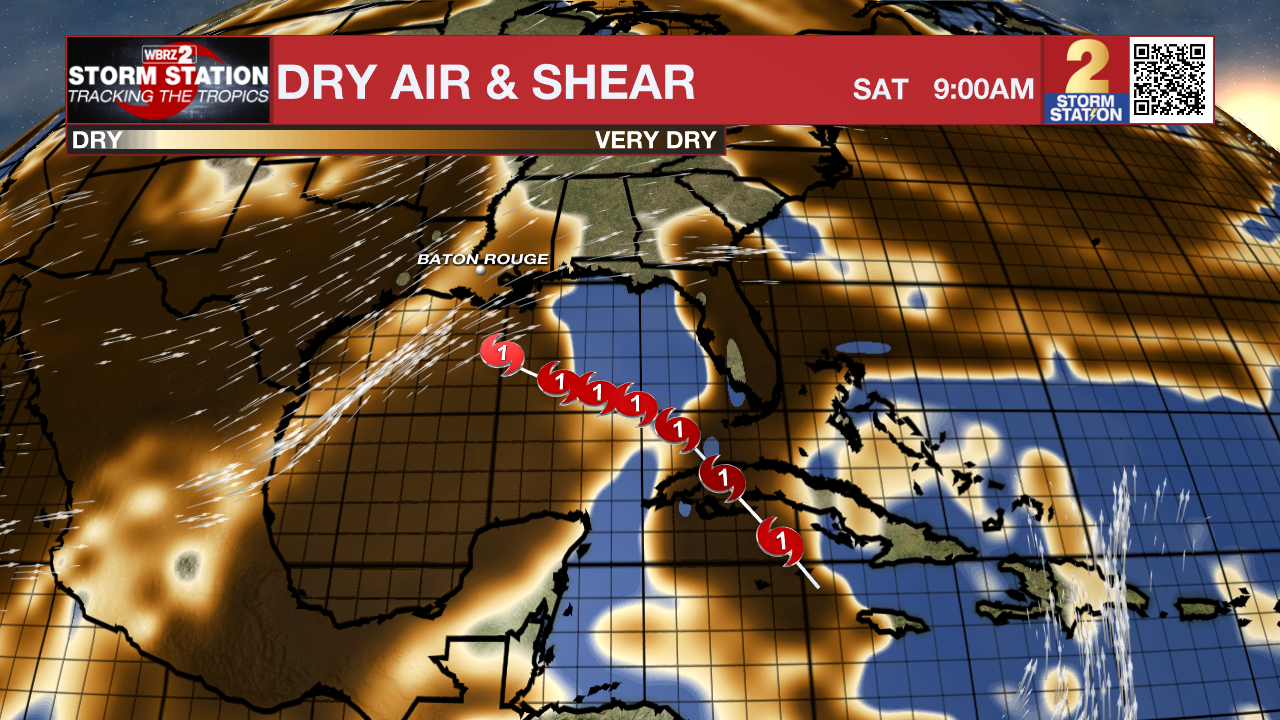
The Storm Station expects the system to be on the weaker side as it passes into the central and northern Gulf of Mexico. Relatively cooler water temperatures, dry air and wind shear will all make a more hostile environment for the storm. At this point, major impacts from the system are highly unlikely. There is still an equal chance of nothing at all or minor, nuisance impacts for the Capital Area. If the local weather is influenced in any way by Rafael, it would be during the Friday through Sunday time period. Stay tuned to the Storm Station Forecast through the week, and bookmark the Hurricane Center for new storm information every three hours.
Get the latest 7-day forecast and real time weather updates HERE.
Watch live news HERE.
The Tropics: Hurricane Rafael continued to strengthen in the Caribbean Sea on Tuesday. Rafael is expected to get a bit stronger before moving across western Cuba on Wednesday. Later this week, the hurricane will emerge in the southeastern Gulf of Mexico and slowly churn northwestward, perhaps not even reaching land before the end of the weekend, if even reaching land at all.

After moving into the Gulf early Thursday, many atmospheric conditions will start to work against the storm, including drier air and wind shear in the upper atmosphere. From an intensity standpoint, because the storm will encounter this more hostile environment, strengthening is very unlikely late this week.
It is worth noting that Louisiana has never experienced a landfall by a named system in the month of November. Should that occur, it would be unprecedented. But with a lack of cold fronts cleanly passing through to help shield the region from the system in the coming days, it is worth monitoring.
The Storm Station is here for you, on every platform. Your weather updates can be found on News 2, wbrz.com, and the WBRZ WX App on your Apple or Android device. Follow WBRZ Weather on Facebook and Twitter for even more weather updates while you are on the go.


