Tuesday AM Forecast: Scattered thunderstorms on Election Day, Rafael to enter Gulf later this week
Those heading to vote on Election Day should pack an umbrella as thunderstorms and showers will be passing through the region today. The Storm Station is also continuing to track a late-season named storm that will enter the Gulf later this week.
Scroll down to The Tropics section for the latest on Tropical Storm Rafael.
Today & Tonight: A few spotty rain showers during the Tuesday morning commute could make for slick roadways. As the day wears on and a cold front inches closer from the west, expected radar activity to pick up. Scattered showers and thunderstorms will move through the region on Tuesday with activity peaking during the afternoon hours. When not raining, conditions will be mostly cloudy and muggy, with temperatures this afternoon in the middle-80s.
Overnight, the front will begin to retreat off to the west, leaving the Capital Area on the warmer side of things. Lows on Wednesday will be in the low to mid 70s with a slight risk for early morning fog development.
Up Next: With the cold front not making a pass through the region and rain chances becoming slim again on Wednesday, temperatures will return to the upper-80s tomorrow afternoon. This will be the trend on Thursday too, with mornings starting off in the 70s. Late week and into the weekend, there are many question marks surrounding the forecast. As of now, the Storm Station 7-day forecast shows the same warm and muggy conditions with only spotty rain activity out of mostly cloudy skies Friday and Saturday. However, the forecast is closely tied to the development and eventual track of a tropical disturbance which will enter the Gulf of Mexico around midweek (see the Tropics section below).
The Storm Station expects the system to be on the weaker side as it passes into the central Gulf of Mexico. Relatively cooler water temperatures, dry air and wind shear will all make a more hostile environment for the storm. At this point, it is unknown whether or not the Capital Region will experience any effects from the system, but if it does, major impacts are unlikely. Stay tuned to the latest forecast this week, as adjustments may or may not be needed closer to the weekend depending on the future track of Rafael. For now, the Storm Station 7-Day Forecast keeps things quiet.
Trending News
Get the latest 7-day forecast and real time weather updates HERE.
Watch live news HERE.
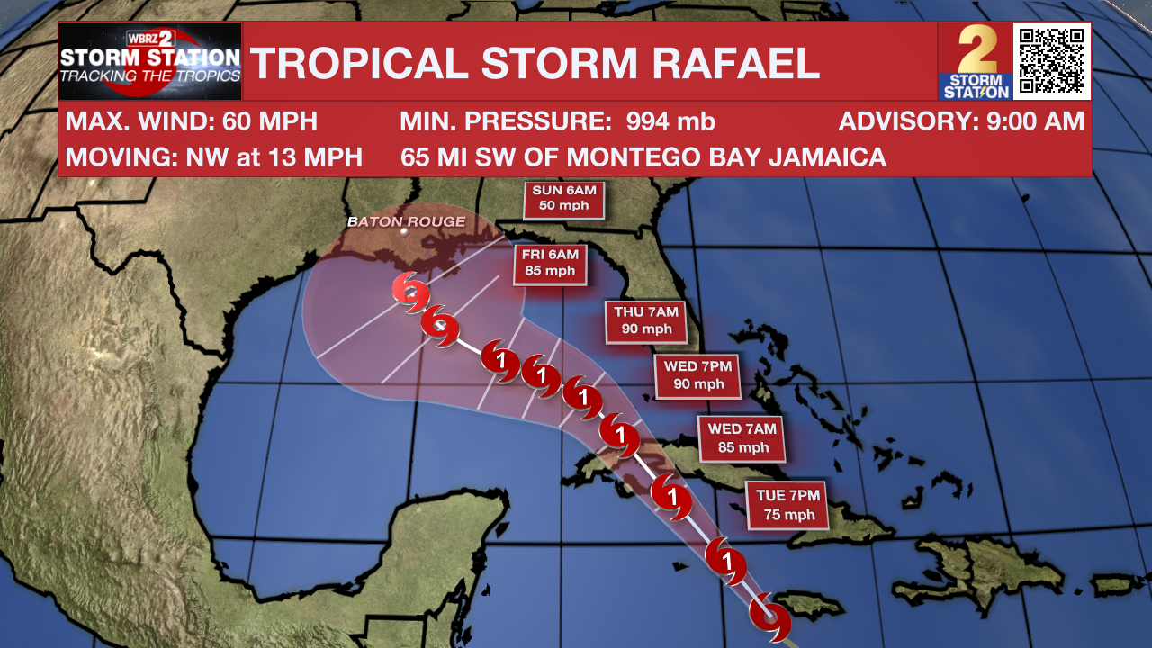
The Tropics: Now Tropical Storm Rafael continues to strengthen in the Caribbean early Tuesday morning. The storm is located 105 miles SW of Jamaica and is forecast to becomes a strong Category 1 storm over the next 24 hours. Rafael will move across western Cuba on Wednesday as a hurricane before making a northwestward turn into the Gulf of Mexico later this week.

After moving into the Gulf early Thursday, many atmospheric conditions could work against the storm; including drier air from the west and wind sheer in the upper atmosphere. This introduces significant uncertainties to the long-term track forecasts. From an intensity standpoint, because the storm will encounter a more hostile environment in the Gulf, additional strengthening will be very unlikely. It is still too far out to know if and where impacts may set up along the Gulf Coast.
It is worth noting that Louisiana has never experienced a landfall by a named system in the month of November. Should that occur, it would be unprecedented. But with a lack of cold fronts cleanly passing through to help shield the region from the system in the coming days, it is worth monitoring.
Another area of low pressure could develop near the northern Leeward Islands in a couple of days. Afterward, some slow development of this system is possible during the latter part of the week while it moves generally westward over the southwestern Atlantic.
- Emma Kate C.
The Storm Station is here for you, on every platform. Your weather updates can be found on News 2, wbrz.com, and the WBRZ WX App on your Apple or Android device. Follow WBRZ Weather on Facebook and Twitter for even more weather updates while you are on the go.


