Monday PM Forecast: No sign of cooler weather; Rafael forms in the Caribbean
Near-record warmth in the mornings and afternoons will continue this week. The Storm Station is also tracking a named system which will soon enter the Gulf of Mexico.
Scroll down to The Tropics section for the latest on Tropical Storm Rafael.
Tonight & Tomorrow: Clouds will increase on Monday night across the Capital Area. A light sprinkle or shower is not out of the question, but most of the night looks dry. It will be incredibly warm with a morning low in the low to mid-70s. This is remarkable since the warmest low temperature on record for Tuesday (Nov. 5th) is 67°. Clearly, the forecast low would exceed the record value by a wide margin. There will also be a healthy breeze overnight out of the southeast at 10-15 mph.
A cold front approaches from the west on Election Day. Most will wake up to mostly cloudy skies, and the clouds will persist through much of the day. Although the cold front never arrives in the Metro Area, it will get close enough to pop some scattered showers and thunderstorms during the day. Coverage will be spotty during the morning and peak during the afternoon. Look for a high temperature in the mid-80s all thanks to increased cloud cover and shower activity. Although slightly cooler, that still runs about 10° warmer than the average high temperature for early November.
Up Next: With rain chances tumbling again on Wednesday, temperatures will go right back up. Highs will reach the upper-80s through Thursday, perhaps challenging a few more records in the process. There are some question marks surrounding the forecast late this week. This is closely tied to the development and eventual track of a tropical disturbance which will enter the Gulf of Mexico around midweek (see the Tropics section below). The Storm Station expects the system to be on the weaker side as it passes into the central Gulf of Mexico. Relatively cooler water temperatures, dry air and wind shear will all make a more hostile environment for the storm. At this point, it is unknown whether or not the Capital Region will experience any effects from the system, but if it does, major impacts are unlikely. Stay tuned to the latest forecast this week, as adjustments may or may not be needed closer to the weekend depending on the future track of Rafael. For now, the Storm Station 7-Day Forecast keeps things quiet.
Trending News
Get the latest 7-day forecast and real time weather updates HERE.
Watch live news HERE.
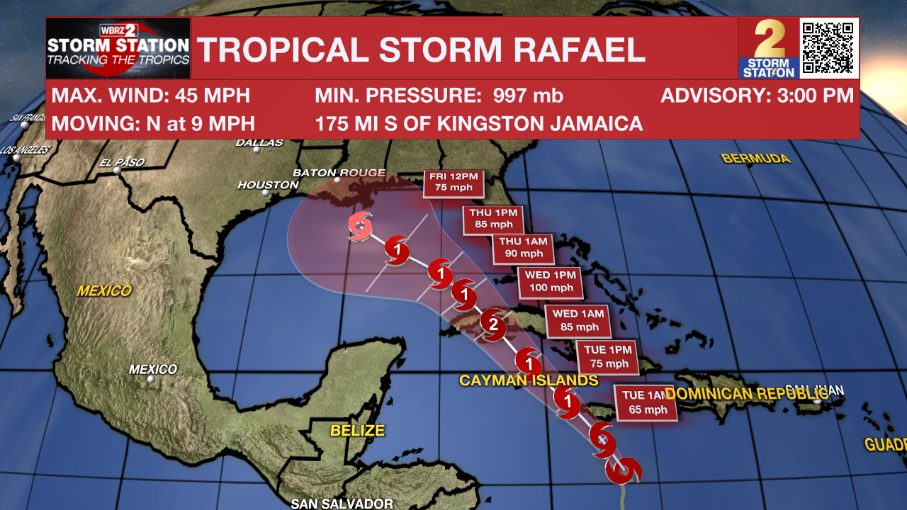
The Tropics: Tropical Depression Eighteen strengthened into Tropical Storm Rafael on Monday afternoon in the Caribbean Sea. This storm had winds topping out at 45 mph and was moving north around 10 mph. Rafael is projected to become a Category 2 hurricane before making landfall across western Cuba Wednesday. The system will then continue on a northwestward trajectory and enter the Gulf of Mexico.

After moving into the Gulf, the steering currents rearrange in a fashion that could allow the system to slow down and meander temporarily. This introduces significant uncertainties to the long-term track forecasts. It is still too far out to know if and where impacts may set up along the Gulf Coast. From an intensity standpoint, the storm will encounter a more hostile environment in the Gulf which would limit additional strengthening.
It is worth noting that Louisiana has never experienced a landfall by a named system in the month of November. Should that occur, it would be unprecedented. But with a lack of cold fronts cleanly passing through to help shield the region from the system in the coming days, it is worth monitoring.
Meanwhile, Tropical Storm Patty became post-tropical on Monday in the North Atlantic. And another area of low pressure could develop near the northern Leeward Islands in a few days. Slow development of that system is possible after that time while generally moving west over the southwest Atlantic.
-- Meteorologist Malcolm Byron
The Storm Station is here for you, on every platform. Your weather updates can be found on News 2, wbrz.com, and the WBRZ WX App on your Apple or Android device. Follow WBRZ Weather on Facebook and Twitter for even more weather updates while you are on the go.


