

Latest Weather Blog
Monday PM Forecast: Soggy night, a quick chill, then more rain not far behind
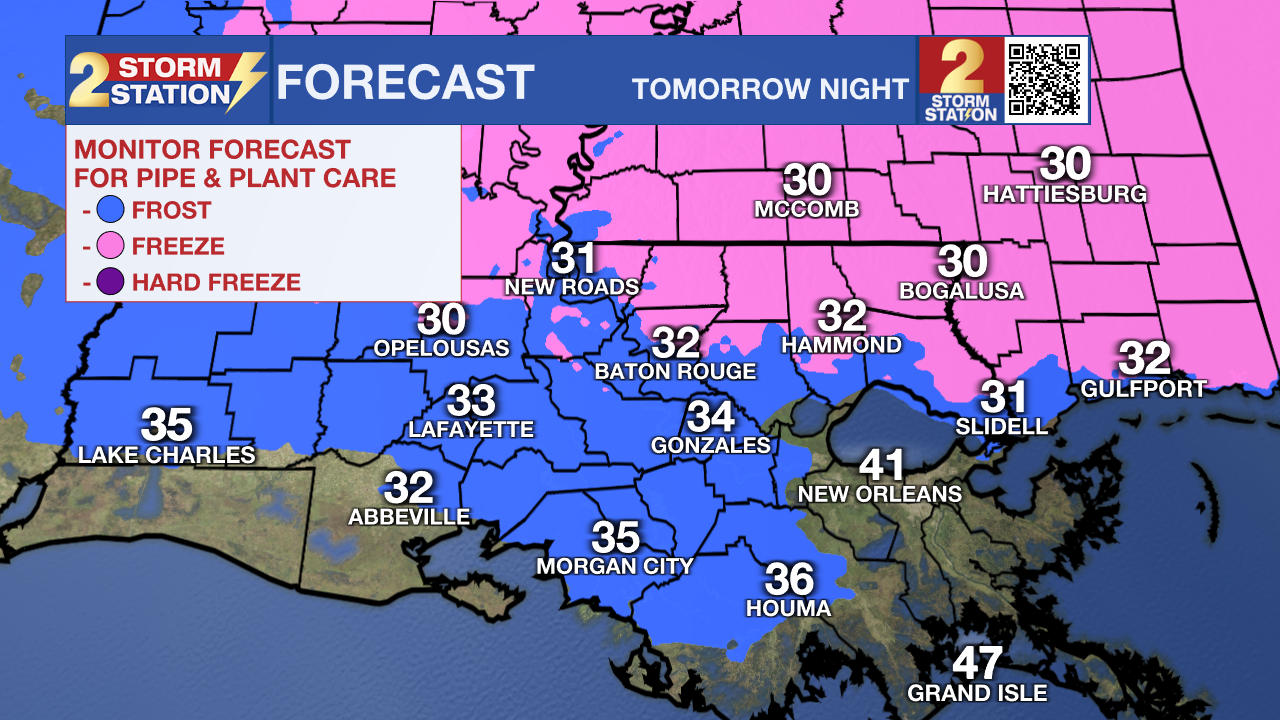
After widespread rain moves out, a brief chill moves in. Many could experience a light freeze by midweek. But another late-week storm system is on the horizon, putting a stop to Jack Frost’s visit.
Tonight & Tomorrow: A steady and widespread rain will roll through the Capital Region during the evening and gradually taper after midnight. No severe weather or flooding issues are expected; it’s just a beneficial soaking rain. Up to 1” will be possible with this round, with only a few communities managing to squeeze out over an inch.

Clouds will hold on through daybreak. While cloud cover tends to keep nighttime lows up, an increasing northwest wind will drive temperatures into the upper 30s and lower 40s by dawn. Skies will clear out through the morning. Expect a chilly Tuesday afternoon with a high in the low 50s, but with a north wind at 10-15 mph, wind chills will sit in the 40s through much of the day.
A Brief Freeze: Temperatures will rapidly drop on Tuesday night. By mid-evening, temperatures will already dip into the 30s. A light freeze is expected along and north of I-10 by sunrise. Areas south of the major highways will still reach the mid-30s, low enough to support frost. Protect people, pets, and plants from the cold early Wednesday. There won’t be any frost or freeze concerns after midweek.
More Waves of Rain: As temperatures rebound into the low 60s on Wednesday afternoon, moisture will begin to gather just offshore, setting the stage for more rain. 1-3” of rainfall is expected with locally higher amounts between Thursday and Friday, spread out across multiple rounds. Such a soaking rain will help the ongoing drought situation in some areas, but if the rain comes too quickly, localized flooding cannot be ruled out. Stay connected with the Storm Station as the forecast comes into a sharper focus. As for the weekend, the trend is leaning drier.
Trending News
Get the latest 7-day forecast and real-time weather updates HERE.
Watch live news HERE.
— Meteorologist Malcolm Byron
The Storm Station is here for you, on every platform. Your weather updates can be found on News 2, wbrz.com, and the WBRZ WX App on your Apple or Android device. Follow WBRZ Weather on Facebook and X for even more weather updates while you are on the go.
More News
