

Latest Weather Blog
Sunday PM Forecast: Multiple waves of rain, with chilly blast in between
The weather will turn more active in the week ahead. Several rounds of rain are expected to start and finish the week, totaling 2-5” with isolated corridors approaching 6”. In between systems, chilly air will take center stage.
Tonight & Tomorrow: Rain has tapered off after an afternoon cold front passage. That will set the stage for a mostly dry Sunday night, aside from the occasional sprinkle or two. A east-northeast breeze will help temperatures slip into the upper 40s by daybreak. Monday will start off cloudy, but rain shouldn’t be an issue for the morning drive as many return to work and school. Still, keep the rain gear handy; another wave of showers will move in from the west during the afternoon as a coastal storm system spins up. This could make for a messy drive home, so be prepared for possible delays on the roads. Rain will become steadier and more widespread during the evening, bringing another soaker to the area. Most are looking at up to an additional inch of rain, with isolated higher amounts not off the table.

Use the slider to advance through the next 24 hours of Futurecast
A Brief Chill: Rain will exit before sunrise Tuesday as the coastal disturbance pulls away. Dry air will rush in behind it, allowing skies to clear quickly and setting up a chilly Tuesday. Highs will struggle to reach the low 50s even with sunshine, and wind will likely make it feel a few degrees cooler. Many will be facing a light freeze, especially along and north of I-10, by Wednesday morning. However, temperatures will rebound into the low 60s by afternoon. Enjoy the improvement while it lasts; conditions will turn cool and soggy again after dark.
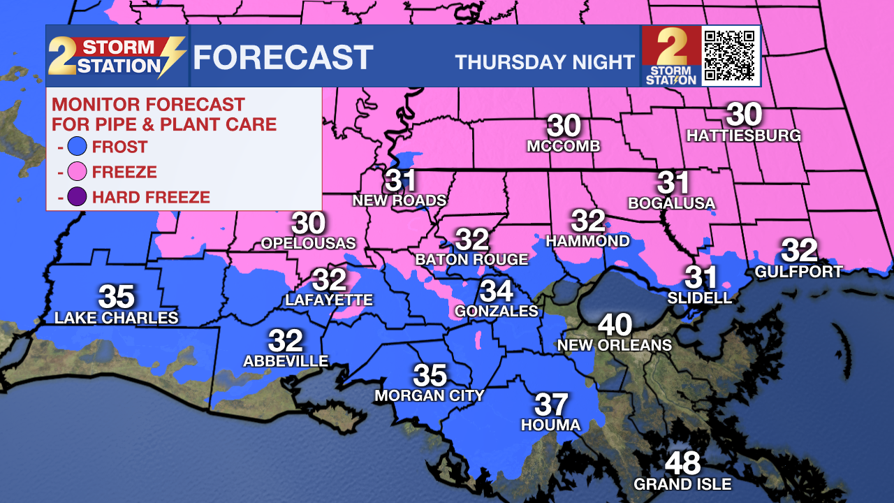
More Waves of Rain: Additional storm systems will spin up by the coast on Thursday and Friday. While it’s still unclear exactly how it will all unfold, confidence is growing that several more rounds of soaking rain will finish out the week. Expect a couple more inches of rain out of it. This would help the ongoing drought in some areas, but if the rain comes too quickly, localized flooding cannot be ruled out. This will be a situation that the Storm Station will monitor throughout the week. Thankfully, the trend for the weekend looks drier.

Trending News
The Tropics: For the Gulf, Caribbean, and Atlantic, all is quiet as hurricane season comes to an end. Daily updates on the tropics on the Storm Station Weather Blog will end starting Monday, December 1, unless the National Hurricane Center designates an area of interest. Otherwise, tropical updates will resume at the start of the 2026 Atlantic Hurricane Season on June 1.
Get the latest 7-day forecast and real-time weather updates HERE.
Watch live news HERE.
— Meteorologist Malcolm Byron
The Storm Station is here for you, on every platform. Your weather updates can be found on News 2, wbrz.com, and the WBRZ WX App on your Apple or Android device. Follow WBRZ Weather on Facebook and X for even more weather updates while you are on the go.
More News
