

Latest Weather Blog
Monday AM Forecast: Heat holds strong as storm chances stay low
Hot and humid conditions will continue much like the weekend, with only limited chances for rain. Coverage will get even lower by mid-week as drier air moves in.
Today & Tonight: For the most part, the same pattern from the weekend will continue today. Expect hot temperatures in the mid-90s, with feels-like temperatures in the triple digits! Heat related illness can happen with these conditions so make sure to drink plenty of water. As for rain coverage, don't expect too much. Although we were watching the chance for a few upper-level disturbances to spice things up a bit, these have trended weaker and further south. This means that coverage of storms should stay spotty (20%) this afternoon and evening. Overnight, skies will turn mostly clear with lows in the mid-70s.
Up Next: Typical summer weather holds firm through Tuesday, with a few spotty to isolated storms possible as weak upper-level disturbances brush by. As we head into midweek, drier air aloft will limit rain chances significantly. After that, attention turns squarely to the heat. Highs in the mid-90s combined with high humidity could bring back heat advisories. Heading into the weekend, increasing moisture will fuel better chances for afternoon storm activity. Still, regardless of the rain, the heat and humidity will remain relentless.
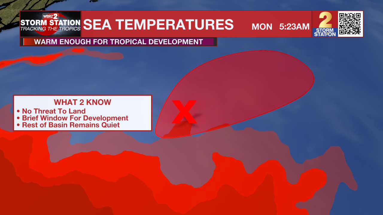
The Tropics:
Showers and thunderstorms continue to show signs of organization overnight with an area of the low pressure located about 500 miles east of Bermuda. Recent satellite-derived wind data also indicates the system has a well-defined surface circulation with maximum sustained winds of 30-35 mph. While environmental conditions are only marginally favorable, only a small increase in organization and persistence of the current shower and thunderstorm activity is likely to result in the formation of a short-lived tropical depression or storm, as soon as later today. By Tuesday, this system is expected to encounter less favorable environmental conditions, ending its opportunity for further development. Regardless of development, the system is forecast to move northeastward at 5 to 10 mph, remaining over the open central Atlantic.
Trending News
Get the latest 7-day forecast and real-time weather updates HERE.
Watch live news HERE.
-- Balin
The Storm Station is here for you, on every platform. Your weather updates can be found on News 2, wbrz.com, and the WBRZ WX App on your Apple or Android device. Follow WBRZ Weather on Facebook and X for even more weather updates while you are on the go.
More News
