

Latest Weather Blog
Thursday PM Forecast: more heat alerts, more highs in the mid 90s
Peak summer heat is back in the forecast, and it’s not going anywhere fast. Highs in the mid to upper 90s will combine with high humidity to push heat index values near or above 108° each afternoon through Saturday. A Heat Advisory will be in effect during these times—so if you have outdoor plans, take plenty of breaks in the shade, drink water often, and know the signs of heat illness.
Tonight & Tomorrow: Isolated showers and thunderstorms will trend down after dark. As skies gradually clear, expect lows in the mid-70s. Friday will be hot and humid with highs reaching well into the mid-90s. Humidity will contribute to feels-like temperatures spending several hours in the 100s. With just spotty showers and thunderstorms possible, more locations will keep the sun around and stay hotter, longer.
Up Next: Through the weekend, heat will remain the number one weather impact. Each afternoon will feature highs in the mid-90s and enough humidity to likely warrant alerts. Scattered afternoon and evening showers and thunderstorms may pop up, most likely with 20–30% coverage each day. While severe weather isn’t expected, some storms could bring gusty winds up to 50 mph, frequent lightning, and downpours that might cause brief street flooding, especially if a storm lingers over one spot.
Heading into next week, high pressure remains in place, keeping temperatures hot—generally in the low to mid 90s—with continued low-end daily storm chances. Even with occasional clouds and showers, the heat and humidity will stay oppressive, so don’t expect much relief until patterns shift.
Trending News
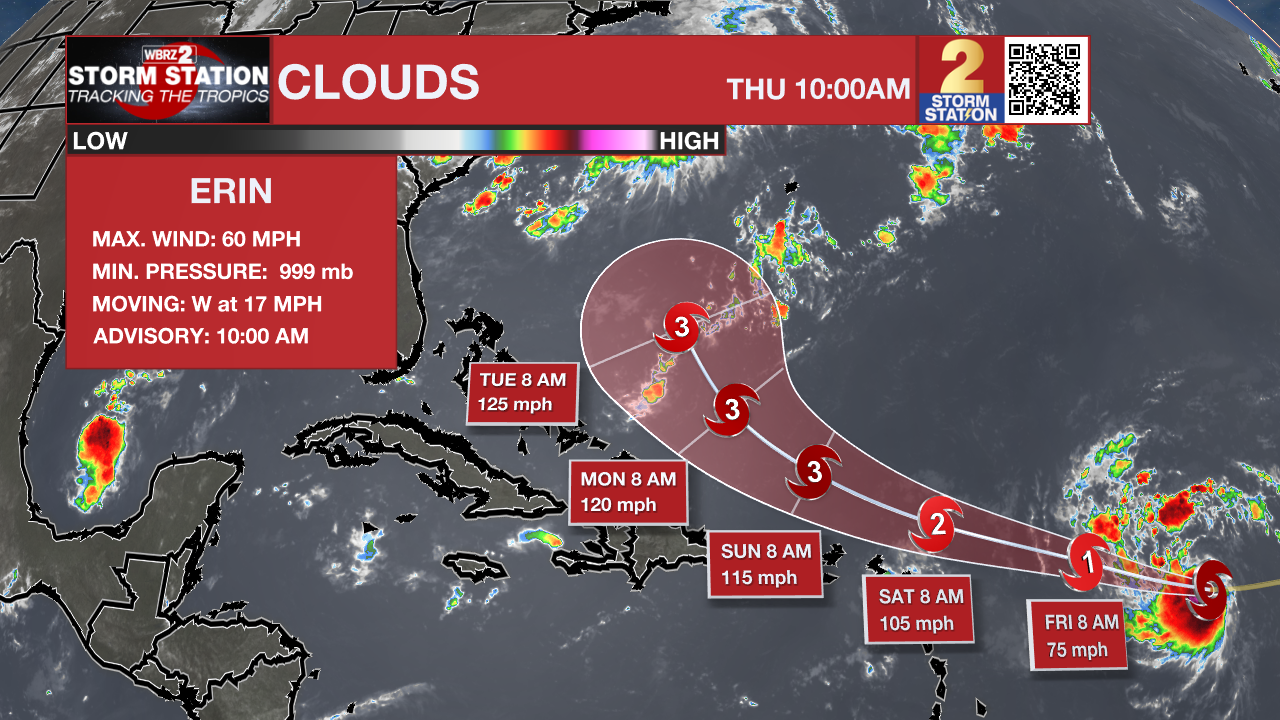
The Tropics: Tropical Storm Erin, located about 890 miles east of the northern Leeward Islands, is strengthening with maximum sustained winds near 60 mph and is expected to become a hurricane by Friday. The storm is moving west at 17 mph and will likely turn west-northwest tonight, bringing its center near or just north of the northern Leeward Islands over the weekend. Residents of the northern Leeward Islands, Virgin Islands, and Puerto Rico should monitor its progress. Swells from Erin could reach these areas by the weekend, creating dangerous surf and rip current conditions.
Showers and thunderstorms have increased in association with an area of low pressure located over the Bay of Campeche. The low is forecast to move west-northwestward across the southwestern Gulf during the next day or so, where environmental conditions are marginally conducive for further development. A tropical depression could form before this system moves inland over northeastern Mexico or southern Texas by late Friday, ending its chances for tropical development.
Get the latest 7-day forecast and real-time weather updates HERE.
Watch live news HERE.
– Josh
The Storm Station is here for you, on every platform. Your weather updates can be found on News 2, wbrz.com, and the WBRZ WX App on your Apple or Android device. Follow WBRZ Weather on Facebook and X for even more weather updates while you are on the go.
More News
