

Latest Weather Blog
Sunday AM Forecast: Another round of heavy rain, storms to start the new workweek
Even with some spotty showers in the forecast, the second half of the weekend will be significantly drier. However, another round of storms lurks. The workweek could start on a soggy note.
Today & Tonight: After a cloudy start, a few cloud breaks will give way to partly sunny skies during the afternoon. Spotty showers will be out and about for much of the day, but it won't be nearly as soggy as Saturday. There will be lots of dry time. Sunshine and a southeast breeze at 7-17 mph will allow highs to soar into the middle and upper-80s across Metro Baton Rouge. Skies will quickly turn cloudy during the evening hours. Expect an incredibly warm night, with lows only reaching the low-70s. And eventually, another round of storms will set foot in the Capital Area–that is our next impact.
Next Impact: A cold front will drive a line of thunderstorms through Louisiana overnight Sunday, into Monday. Per the latest data, these storms appear to arrive around daybreak and stick around through the Monday morning commute. That said, minor shifts in the local timeline are still possible as the storms have yet to develop. They will do so by early Sunday evening, and the details should be clearer by then. The ingredients will be in place for a few strong storms. The main threat would be gusty winds and perhaps a brief spin-up tornado or report of hail up to quarter-size. This is not something everyone would see, only a few point locations.
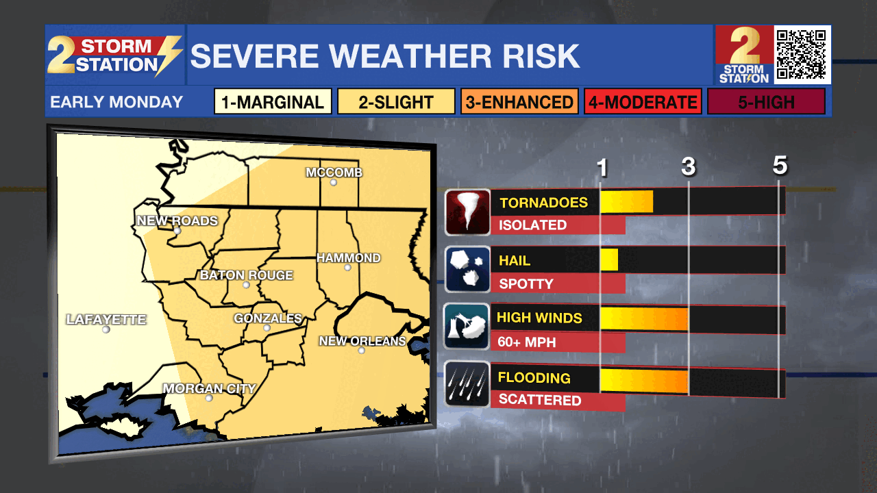
Flooding will be a consideration with this round of rain, especially after Saturday’s deluge. A quick 1-2” of accumulation is the expectation, but locally higher amounts are not off the table. Standing water or poor drainage flooding cannot be ruled out in areas that experience any localized spikes in rainfall. Fortunately, this system is somewhat fast-moving. Conditions should improve by Monday afternoon with nothing more than a few lingering clouds and showers.
Start of April: A warming trend will take place through the remainder of the week, sending afternoon highs Wednesday through Friday into the upper-80s. Records might be challenged on a few occasions. A mixture of sun and clouds will accompany the warmth. A noticeable breeze will pick up late in the week ahead of the next frontal passage.
Trending News
Get the latest 7-day forecast and real-time weather updates HERE.
Watch live news HERE.
-- Meteorologist Malcolm Byron
The Storm Station is here for you, on every platform. Your weather updates can be found on News 2, wbrz.com, and the WBRZ WX App on your Apple or Android device. Follow WBRZ Weather on Facebook and X for even more weather updates while you are on the go.
More News
