

Latest Weather Blog
Wednesday Morning Video Forecast
Related Story
Close-to-perfect Spring weather continues through the second half of the week and into the weekend. For those who are planning to take advantage of the great outdoor conditions, don't forget to wear sun protection as UV rays ramp up this time of year.
Today & Tonight: Full sunshine again today will quickly warm cool morning conditions; look for temperatures near 60 degrees by mid-morning and well into the 70s all afternoon. The Capital City will near 77 degrees for a high today, which is right on par for this time of year. A slight warming trend into Thursday will result in morning lows a few degrees milder than previous days, falling near 52° overnight tonight.
Up Next: The warmest day of the week is expected on Thursday as highs climb into the low 80s. After the warm and mostly sunny day, a weak cold front will pass through overnight, putting a halt to the short-lived warming trend.
Weekend: This weekend's forecast is as close to picture-perfect as things get in South Louisiana. Cool mornings in the upper-40s to mid-50s will quickly warm near average each afternoon. Friday and Saturday will sport afternoon highs in the middle-70s, while Sunday may touch 80 degrees again. The air remains humidity-free, and even winds will stay in check, around 10 mph each day. For those heading out to the Ponchatoula Strawberry or French Quarter Festival this weekend, rain will not be around to interrupt your outdoor plans. However, it is encouraged to use sunscreen as the UV index continues to increase each day to avoid an unnecessary burn.
Next Week: Highs will make a return to the mid-80s to start the next workweek with the same sunny and mainly dry conditions.
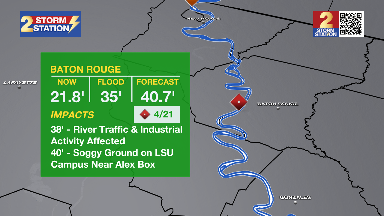
River Flooding: The National Weather Service has issued a RIVER FLOOD WARNING for the Mississippi River At Red River Landing from Thursday evening until May 3. Flood stage is 48 feet. Moderate flooding is expected with a crest near 58 feet on April 22. At these levels, Angola farmland on the left bank becomes inundated. Caution is urged when walking near riverbanks.
The National Weather Service has issued a RIVER FLOOD WATCH for the Atchafalaya River at Simmesport, Butte La Rose, and Morgan City until further notice.
- At Simmesport, flood stage of 40 feet may be reached by April 24. There will be flooding of areas inside the levees of the Atchafalaya Floodway and considerable flooding in the backwater storage area in Avoyelles Parish.
- At Butte La Rose, flood stage of 20 feet may be reached by April 25. Minor flooding of the nearby areas could occur.
- At Morgan City, flood stage of 6 feet may be reached by April 15. At 7 feet, buildings at the foot of Ann Street on the river side of the flood wall will flood as water overtops the Rio Oil Company dock. Buildings on the river side of the Berwick floodwall will flood. River traffic restrictions will be strictly enforced. In addition, backwater flooding could potentially impact portions of areas around Lake Palourde and Stephensville.
Get the latest 7-day forecast and real-time weather updates HERE.
Watch live news HERE.
– Emma Kate C.
The Storm Station is here for you, on every platform. Your weather updates can be found on News 2, wbrz.com, and the WBRZ WX App on your Apple or Android device. Follow WBRZ Weather on Facebook and X for even more weather updates while you are on the go.
News
