

Latest Weather Blog
Tuesday morning video forecast
Related Story
A major shift in the weather pattern is right around the corner. As the week unfolds, atmospheric moisture will climb sharply, bringing back a muggy, humid feel to the air. This surging moisture will set the stage for unsettled weather, increasing the risk of showers and thunderstorms that could impact outdoor plans and events this weekend.
Today & Tonight: While the morning starts on a muggy note, daytime heating will help mix down drier air, dropping humidity levels back to comfortable ranges for most inland locations Tuesday afternoon. High temperatures will remain unseasonably warm, topping out in the low-to-mid 90s. While a spotty daytime shower can't be entirely ruled out, the vast majority of the region will stay dry. Expect clearing conditions overnight, with gentle cooling allowing temperatures to drop into the upper 60s and lower 70s.
Up Next: Moisture levels will begin ramping up on Wednesday, setting the stage for significantly higher humidity starting Thursday and lasting through the weekend as tropical air pushes in from the Gulf and stalls overhead. Over the next seven days, widespread rainfall totals of 1 to 3 inches are expected, with localized areas seeing higher amounts. While current modeling points toward the highest rain totals falling just to the east and west of the metro area, the deep moisture in place will keep the risk of heavy downpours high across the immediate region. Any heavier storms could produce quick rainfall rates of 2 to 3 inches per hour, which may temporarily overwhelm drainage networks and trigger localized street flooding.

Between high school football action on Friday night, Southern's homecoming festivities, and LSU taking on McNeese, the Capital Region is packed with outdoor events this weekend.
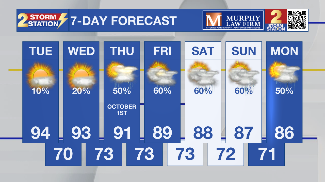
Get the latest 7-day forecast and real-time weather updates HERE.
Watch live news HERE.
The Tropics: Tropical Storm Hanna officially developed over the open waters of the central Atlantic on Monday.

Meanwhile, Fay has re-strengthened back into a tropical storm. The system is drifting slowly to the southwest over open water and is expected to transition into a post-tropical low by midweek, remaining far from any landmass and posing no threat to populated areas.
— Balin
The Storm Station is here for you, on every platform. Your weather updates can be found on News 2, wbrz.com, and the WBRZ WX App on your Apple or Android device. Follow WBRZ Weather on Facebook and X for even more weather updates while you are on the go.
News

