

Latest Weather Blog
Sunday Night Video Forecast
Related Story
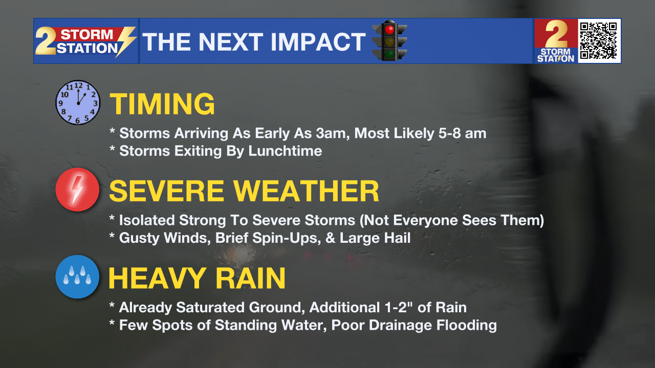
Moving into the new workweek, another round of showers and thunderstorms will blow through the Capital Area. Impacts appear increasingly likely for the Monday morning drive.
Tonight & Tomorrow: Clouds will quickly return during the evening hours. Expect a cloudy night with temperatures dipping into the upper-60s by morning. Eventually, a cold front will drive another round of heavy rain and storms into the Capital Area. The storms could move into the region as early as 3 a.m. or as late as 9 a.m., but most likely somewhere in the middle of that window. That would cause problems for the morning commute. Heavy rain will move through from northwest to southeast, finally exiting the Storm Station’s 13 parish, 2 county coverage area by lunchtime. Partial clearing is expected during the afternoon which will help nudge highs into the lower-80s. The added warmth might allow for re-destabilization of the atmosphere by mid to late afternoon. And with a cold front in the region, an isolated storm is not off the table on Monday afternoon. However, afternoon rain would be the exception as opposed to the rule.
Severe Weather Risk – A Level 3/5 risk of severe weather is in effect near the LA-MS state line for Monday morning's storms. These areas, primarily north of Baton Rouge, may see a slightly greater coverage of severe weather. A Level 2/5 risk of severe weather is in place elsewhere. This highlights the potential for a few strong storms, with only isolated point locations experiencing them – not necessarily everyone. Nevertheless, the Storm Station believes the severe risk is slightly greater with this round of rain as the storms will feel the influence of the cold front. The main threats would be gusty winds and perhaps a brief spin-up tornado or report of hail up to quarter-size.
Flash Flooding Risk – Flooding will be a consideration with this round of rain, especially after Saturday’s deluge. A quick 1-2” of accumulation is expected for many, but locally higher amounts are not off the table. Standing water or poor drainage flooding cannot will be a possibility in areas that experience any localized spikes in rainfall. Be extra cautious while driving in the morning and look out for areas of water on the roads.
Have alerts turned on in anticipation of any possible weather warnings. Also 2une-In with Meteorologist Emma Kate Cowan beginning at 5 a.m. on WBRZ before stepping outside to avoid getting caught off guard by nasty weather during the commute.
Up Next: A warming trend will take place through the remainder of the week, sending afternoon highs Wednesday through Friday into the upper-80s. Records might be challenged on a few occasions. A mixture of sun and clouds will accompany the warmth along with a few hit-or-miss showers. It will also get quite breezy starting Wednesday. Wind speeds will remain elevated through Saturday in anticipation of another cold front. The associated frontal passage will bring another dose of rain into Sunday, and knock temperatures down several notches into the following week.
Get the latest 7-day forecast and real-time weather updates HERE.
Watch live news HERE.
-- Meteorologist Malcolm Byron
The Storm Station is here for you, on every platform. Your weather updates can be found on News 2, wbrz.com, and the WBRZ WX App on your Apple or Android device. Follow WBRZ Weather on Facebook and X for even more weather updates while you are on the go.
News
