

Latest Weather Blog
Saturday Morning Video Forecast
Related Story
Following on-and-off showers and storms through Saturday afternoon, drier conditions will take over on Sunday before another round of storms arrive Monday morning. Keep the Storm Station Weather App handy for rain and lightning alerts!
Here’s a breakdown of what to expect:
- Through Saturday afternoon: Off and on heavy rain and spotty strong thunderstorms
- Saturday Evening: Mostly dry, mild
- Sunday: Mostly dry and warm—best day for outdoor plans
- Monday morning: Another round of storms, possibly strong
- Tuesday to Friday: Warming up, mostly dry, becoming breezy
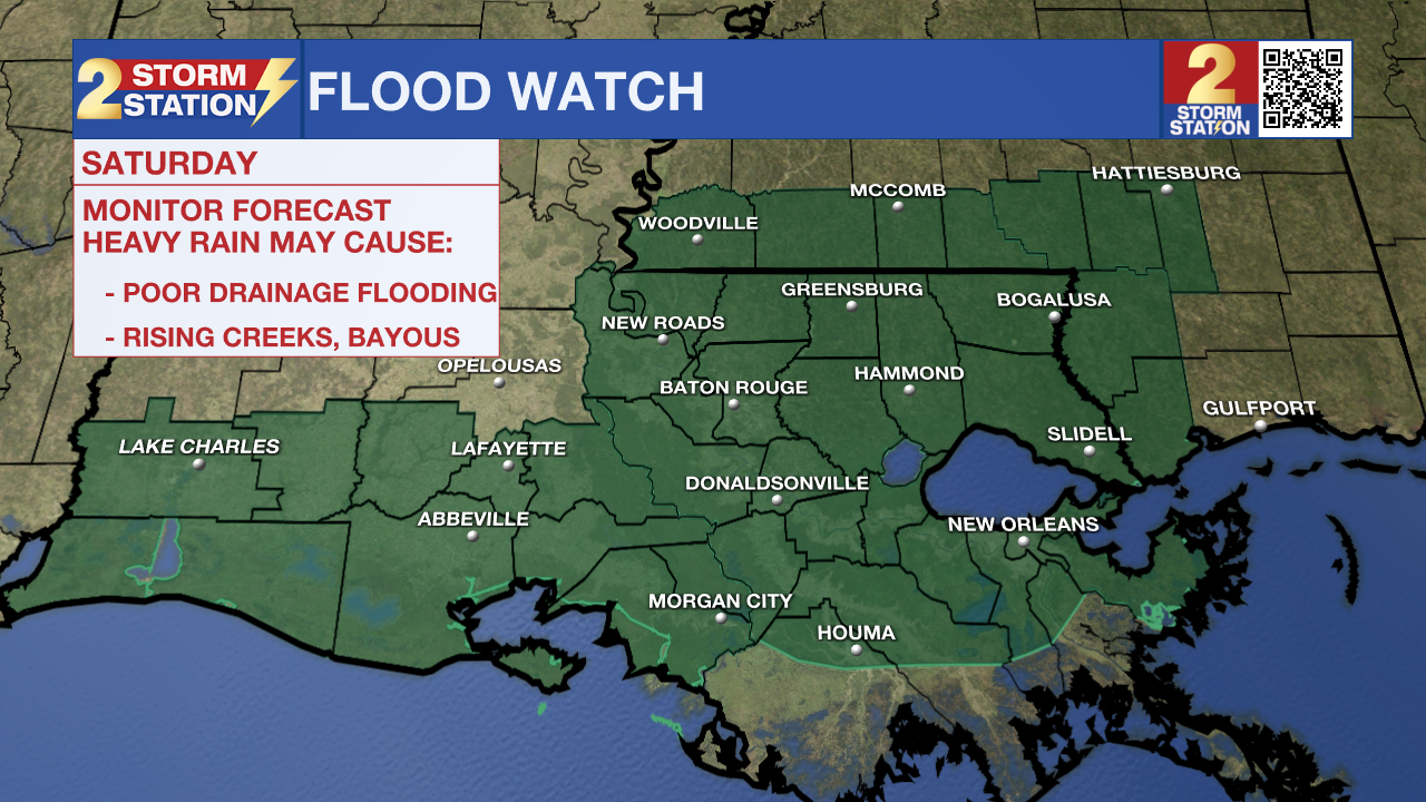
Today: Rain showers and occasional thunderstorms will continue to roll through the Capital Area on Saturday. A Flood Watch remains in place for southeast Louisiana today because of the threat for heavy downpours leading to localized flash flooding issues across the region. As passing showers continue on-and-off throughout the morning and early afternoon hours Saturday, between 1-3" of rainfall accumulation is expected, with some areas picking up more. These storms also hold the threat for gusty winds and hail.
There will be dry periods between passing storms and by late Saturday afternoon, much of the radar activity will be pushing east. Temperatures throughout the day will be mild, starting off in the mid-60s and warming near 80 degrees as the rain exits this afternoon. Conditions should be improving for LSU Baseball to eventually play later today.
Tonight: Clouds will stick around overnight, limiting temperatures to a mild 67° early Sunday morning. Besides a spotty shower or two, conditions will be much drier as we move into the second half of the weekend.
Sunday: Besides a rogue pop-up shower or two, Sunday will be largely dry and warm with a mix of sun and clouds during the afternoon hours. Look for highs tomorrow in the mid-80
Up Next: The next frontal system will bring a quick round of storms early Monday morning. This round of storms holds the potential for stronger cell development and could make for a messy early morning commute. The Storm Station will be monitoring the threat for heavy rain, gusty winds, and even an isolated tornado.
By Monday afternoon, drier and quieter conditions will take over and stick around into the start of April. A warming trend will take place next week, sending afternoon highs Wednesday through Friday into the upper-80s.
Get the latest 7-day forecast and real-time weather updates HERE.
Watch live news HERE.
– Emma Kate C.
The Storm Station is here for you, on every platform. Your weather updates can be found on News 2, wbrz.com, and the WBRZ WX App on your Apple or Android device. Follow WBRZ Weather on Facebook and X for even more weather updates while you are on the go.
News
