

Latest Weather Blog
Monday Morning Video Forecast
Related Story
The new week kicks off with familiar afternoon storms, but just in time for the 4th of July holiday, drier and hotter weather is expected to return. Meanwhile, the Storm Station is keeping an eye on the Gulf for potential tropical development.
Today & Tonight:
Expect a sunny and mild start to Monday with morning temperatures in the 70s. Highs will reach the low 90s, with scattered afternoon showers and storms. Some haze may be visible due to Saharan dust, which could be irritating for those sensitive to air quality. Any lingering rain will fade after sunset, leaving us with clear skies and overnight lows in the mid-70s.
Midweek Outlook:
While the heaviest moisture this week will stay closer to the Gulf Coast states east of us, southern Louisiana will still see scattered storms each afternoon through Wednesday. Not everyone will get rain every day, but keep an eye out for downpours and occasional thunder. Highs will hover in the low 90s under partly sunny skies. By Thursday, drier air will begin to move in, gradually lowering rain chances—though the exact timing is still uncertain.
4th of July & Weekend:
Rain chances will taper off just in time for the holiday. Most locations will stay dry on Friday and Saturday as sunshine takes over. With fewer storms around, heat will build—highs in the mid 90s and heat indices possibly prompting a Heat Advisory. Stay cool and hydrated if you’re celebrating outdoors. Evening fireworks displays are looking good so far. We’ll also be keeping a close watch on the Gulf for any tropical activity heading into the weekend.
The Tropics: After making landfall Sunday evening in eastern Mexico, now only remnants of what was Tropical Storm Barry remain Monday morning.
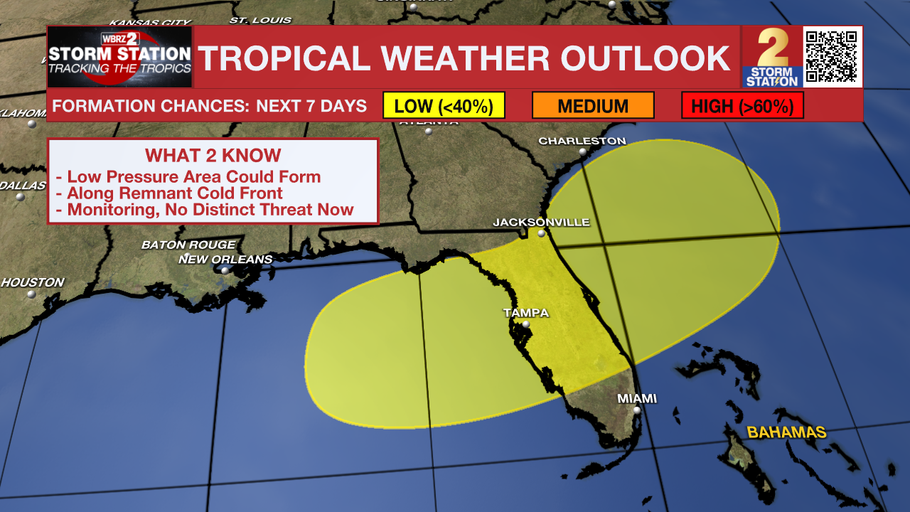
Meanwhile, the National Hurricane Center has highlighted parts of the Southeast U.S. Atlantic and Gulf Coasts as an area to watch. Over the holiday weekend, an area of low pressure could develop along a remnant front in the region. Gradual tropical or subtropical development could occur thereafter as it drifts slowly off the coastline. At this time, there is no distinct threat to the local area. The Storm Station will be monitoring this throughout the week.
Get the latest 7-day forecast and real-time weather updates HERE.
Watch live news HERE.
— Emma Kate C.
The Storm Station is here for you, on every platform. Your weather updates can be found on News 2, wbrz.com, and the WBRZ WX App on your Apple or Android device. Follow WBRZ Weather on Facebook and X for even more weather updates while you are on the go.
News
