

Latest Weather Blog
Wednesday PM Forecast: a wet day before quiet weather returns
The next batch of rain will arrive on Thursday. Dry and quiet weather will follow into the weekend.
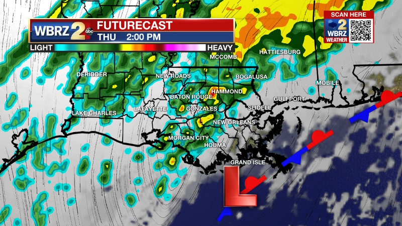
Tonight & Tomorrow: Continued cloud cover is expected overnight with an isolated shower or some drizzle in the mix as well. It will still feel chilly out there with lows in the upper 40s. On Thursday, the slow moving front responsible for this week’s dreary weather, will start to get a push east of the area. A Intermittent rain and a few thunderstorms will deliver another inch or so through the day. A pocket of perhaps two inches is possible, but many locations will actually fall shy of an inch. Though less than Sunday, since the ground is saturated and rivers are elevated, areas where the highest totals occur will need to be monitored for standing water issues and minor stream flooding.
Up Next: On Friday, the front will continue to move east of the area with gradually clearing skies and cooler, drier air. As sun returns, highs will stop in the upper 50s followed by a night of lows in the low 30s. A light freeze is even possible for the Metro Area and points to the north and east. A dry and seasonable weekend is ahead. Saturday will sneak into the low 60s and Sunday will make it into the upper 60s. The next rain should be holding off until at least the middle of next week.
Trending News
Get the latest 7-day forecast and real time weather updates HERE.
Watch live news HERE.
Detailed Forecast: An upper level trough of low pressure will move across the Gulf Coast on Thursday helping to push a stalled front further east and away from the local area. As this occurs, a plume of moisture will move north, just ahead of the upper level trough. A period of intermittent, moderate rain is expected across the region. While the rainfall rates or totals will not be as significant as Sunday, there are likely to be a few small pockets of two inches. If one of these amounts happens to fall near I-12 through East Baton Rouge, Livingston or Tangipahoa Parishes, it could reaggravate some of the standing water and river flooding issues we have seen since the previous event. However, most of the forecast area will only receive an inch or less out of this event. In terms of timing, the bulk of the rain will fall in between the two commutes, from late morning through late afternoon. Lighter showers will persist overnight while the stubborn front slowly chugs east. As the associated upper level trough pulls away on Friday, skies will gradually clear from northwest to southeast. Since there is a very cold air mass to our northwest, winds out of that direction behind the front should send temperatures tumbling toward freezing Friday night into Saturday. A freeze will be possible from the Metro Area northward into Mississippi. A weak upper level ridge will move across the Gulf Coast on Saturday and Sunday leading to high temperatures warming by about five degrees each day with the 70s possible by Monday. The next chance for rain could come around Tuesday or Wednesday of next week. Confidence in that possibility is low at this time as model results are in very poor agreement with the ECMWF bringing another decent soak and the GFS keeping things totally dry. Expect guidance to come together better by the weekend.
--Josh
The Storm Station is here for you, on every platform. Your weather updates can be found on News 2, wbrz.com, and the WBRZ WX App on your Apple or Android device. Follow WBRZ Weather on Facebook and Twitter for even more weather updates while you are on the go.
More News
