

Latest Weather Blog
Tuesday AM Forecast: South Louisiana stuck in classic summertime pattern, More areas to monitor in Tropics
Daily storm coverage backs off a bit through midweek, but the heat and humidity does not! Another Heat Advisory will be in effect Tuesday as less of the region will see nature's "air conditioning", aka afternoon storms, this afternoon.
Today & Tonight: Tuesday starts off sunny and warm before quickly turning hot and humid as clouds increase. By the afternoon, expect partly sunny skies with highs in the mid-90s and feels-like temperatures pushing near 108°, prompting another round of heat alerts. Isolated summertime storms will flare up during the afternoon and early evening, bringing the risk of gusty winds, heavy rain, and frequent lightning. About 40% of the Capital Region will see storms today. Overnight, conditions will calm and skies will clear, with lows settling into the low to mid-70s.
Up Next: The classic summer pattern continues through midweek with hot, sunny days and isolated afternoon storms. By late week, tropical moisture builds ahead of a weak front to the northwest. Friday looks most active, though a scattering of storms is possible Thursday and Saturday as well. Extra showers each day will help knock daytime highs down a bit, to the lower 90s ahead of daily storms. Rain coverage will ease Sunday and Monday, as we track an incoming front that may be able to sneak in early next week. A real cooldown or drop in humidity is unlikely at this point, but not impossible. Keep checking back in with the Storm Station for the latest.
The Tropics:
Hurricane Erin: Erin remains a Major Category 3 hurricane as of Tuesday morning, located east of the Bahamas. The storm will likely maintain its intensity for another day or so before slowly losing strength by mid to late week. Fortunately, Erin will not bring direct land impacts as it will track between the East Coast and Bermuda. However, its massive size could result in tropical storm-force winds clipping the Outer Banks of North Carolina. Tropical Storm and Storm Surge Watches have been posted for those areas. Possible coastal flooding and inundation of local highways along the Outer Banks have also prompted evacuations. Impacts will be even more far-reaching, with rough surf and dangerous rip currents being felt along the entire East Coast.
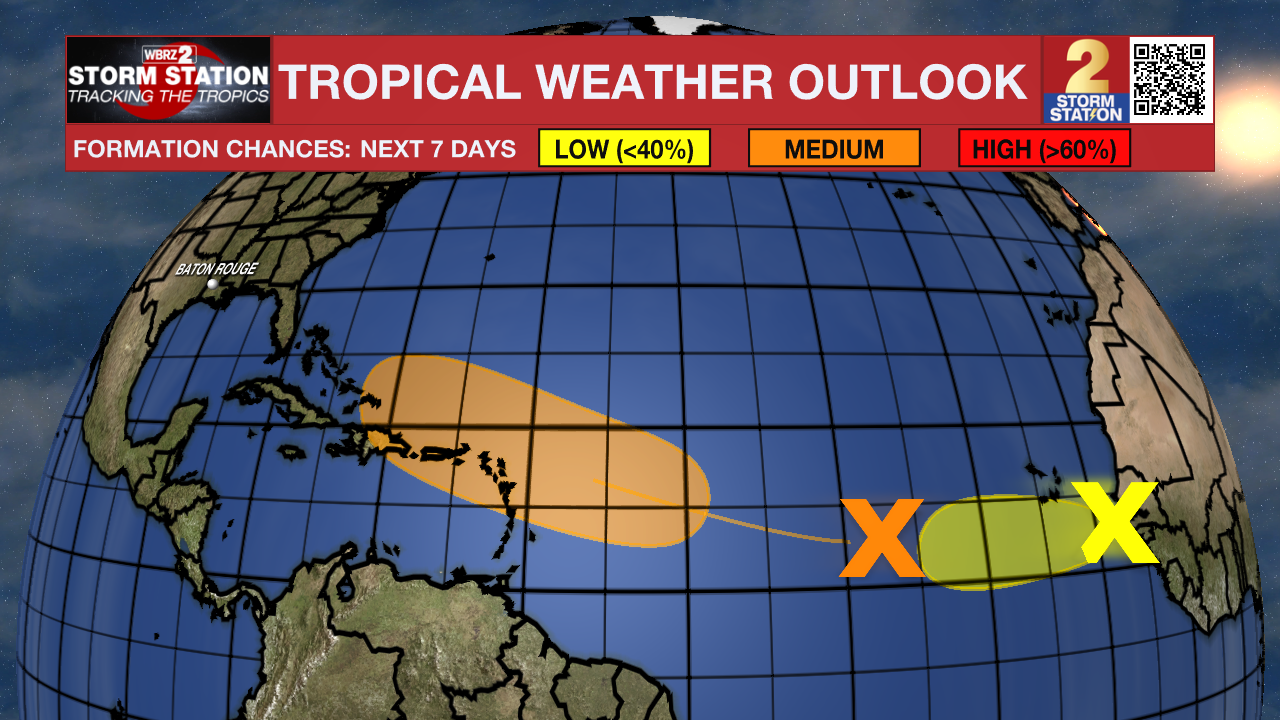
Central Tropical Atlantic: A tropical wave located over the central tropical Atlantic continues to produce a broad area of disorganized showers and thunderstorms. Environmental conditions appear conducive for gradual development of this system, and a tropical depression could form toward the end of the week or weekend. This system should move westward to west-northwestward at about 20 mph across the central tropical Atlantic and approach the vicinity of the Leeward Islands on Friday.
Trending News
Eastern Tropical Atlantic: A tropical wave located a few hundred miles to the southeast of the Cabo Verde Islands continues to produce a concentrated area of showers and thunderstorms. Environmental conditions appear generally favorable for additional development over the next couple of days as the system moves westward at around 15 mph. Towards the end of this week, this system could encounter a less favorable environment, limiting its development chances after that time.
Get the latest 7-day forecast and real-time weather updates HERE.
Watch live news HERE.
— Emma Kate C.
The Storm Station is here for you, on every platform. Your weather updates can be found on News 2, wbrz.com, and the WBRZ WX App on your Apple or Android device. Follow WBRZ Weather on Facebook and X for even more weather updates while you are on the go.
More News
