

Latest Weather Blog
Tuesday AM Forecast: Scattered storms today, daily rain chances through end of week
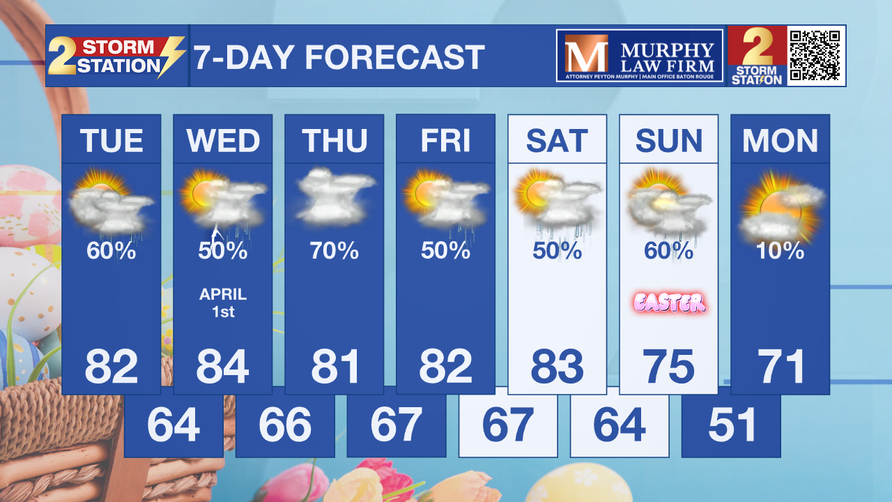
Daily rain chances and unseasonable warmth will continue through the workweek as a moist, unsettled pattern takes hold. However, we are tracking a cold front that could cool us down a bit for Easter Sunday.
Today & Tonight: Another round of pop-up showers and storms will start bubbling up around noon and continue through the afternoon hours. You’ll definitely find plenty of dry windows to get things done, but it’s a good idea to have the rain gear on standby. About 60% of the area can expect a quick drenching at some point today. Temperatures will generally top out in the low 80s, though some neighborhoods might stay a bit cooler thanks to rain-cooled air. Activity will taper off overnight, with temperatures settling in the mid-60s.

Up Next: Expect this unsettled, damp pattern to stick around right through the tail end of the week. You won't necessarily get rained on every single day, but scattered showers and storms will definitely be a daily fixture each afternoon. We aren't looking at any total washouts, though some days will certainly be "busier" on the radar than others. Thursday stands out as the likely peak of the week, as an upper-level disturbance swings through to trigger a higher concentration of storms. By this time next week, most neighborhoods should have picked up between 1" and 3" of total rainfall, with a few spots potentially seeing even more. While severe weather and widespread flash flooding is unlikely, keep in mind that some storms could still pack some gusty winds or cause quick ponding on the roads in isolated areas.
Easter Weekend: Expect this warm and active weather pattern to hold firm as we head into much of Easter weekend. However, we are tracking a cold front that will slide into the picture by Easter Sunday itself. We’re becoming more confident that this front will successfully knock our temperatures down for the holiday, but it looks like a lot of moisture is going to get trapped behind it. The most likely scenario for Sunday is a cooler, gray, and damp day across the region. If your holiday plans involve a crawfish boil, a backyard cookout, or the traditional egg hunt, you’ll definitely want to have an indoor "Plan B" ready to go in case those showers and storms move in. Be sure to stay tuned to the Storm Station as we fine-tune the exact timing of this front.
Trending News
Get the latest 7-day forecast and real-time weather updates HERE.
Watch live news HERE.
— Balin
The Storm Station is here for you, on every platform. Your weather updates can be found on News 2, wbrz.com, and the WBRZ WX App on your Apple or Android device. Follow WBRZ Weather on Facebook and X for even more weather updates while you are on the go.
More News
