

Latest Weather Blog
Sunday PM Forecast: tropical moisture will create a heavy rain threat early next week
Beryl is strengthening, and will make landfall in Texas tonight as a hurricane. While Texas will get most of the impacts, tropical moisture will create the threat for heavy rain early in the week.
Tonight & Tomorrow: Beryl is already starting to influence the local area. Sinking air on the outskirts of the system and dry air wrapping around it has limited rainfall across the area for most of the day. Some outer rain bands will try to move through the area this evening and tonight, but the previously mentioned dry and sinking air will keep storms isolated in nature. Lows will be near 78 degrees under mostly cloudy skies.
Drier air should stay in place through Monday morning, but the air should begin to moisten up by the afternoon and evening. This will create scattered pop up storms and mostly cloudy skies. Before any rain, the heat will be in full force once again. Highs will be near 96 degrees, with feels like temperatures up to 112 degrees.
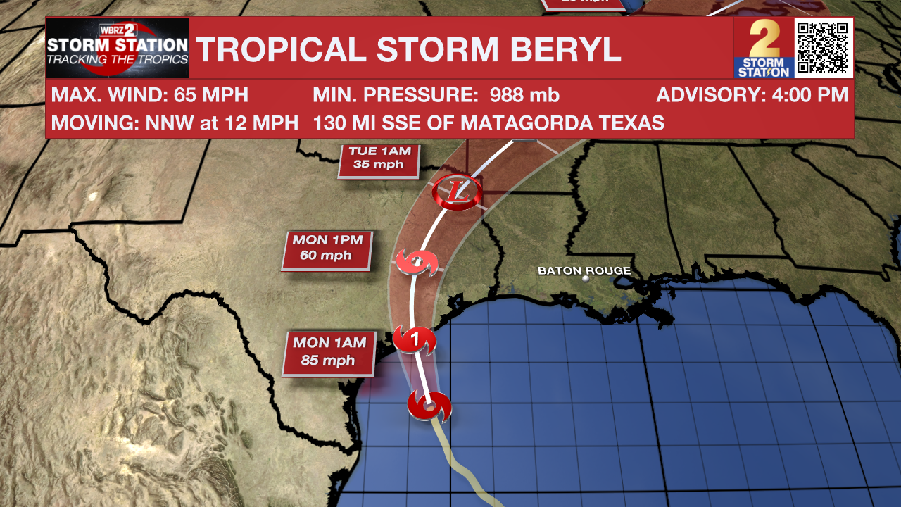
Up Next: The greatest influence from Beryl will be Monday night and throughout the day on Tuesday. A string of very high moisture content will setup over southeast Louisiana with the outer bands. Exactly where these bands setup and the exact timing they move through is still being worked out. Regardless, most will see rain Monday night and Tuesday. Moisture will be high enough for flash flooding to become an issue in some isolated areas. Highs will be limited to the lower 90's. Beryl should begin to pull away by Tuesday evening. The rest of the week and into the weekend will feature a very summer like pattern. It will be hot, humid, and feature afternoon pop up storms.
The Tropics: Tropical Storm Beryl is non its final approach to Texas. Hurricane and tropical storm warnings have been posted. As of 4pm Sunday, Beryl had 65mph winds and was moving NNW at 12mph. The storm will likely intensify to hurricane strength before a landfall in Texas tonight. Areas in the hurricane warning may expect storm surge along the coast, strong winds and heavy rain.
Trending News
Local Impacts: Beryl will bring some indirect impacts to the local area early next week. Here is a summary:
- Rip Currents—dangerous rip currents will be possible along the Louisiana Coast and for beaches as far east as the Florida Panhandle. Extreme caution should be used in areas that are permitting swimming.
- Coastal Flooding—persistent onshore winds could lead to water inundation for immediate coastal areas around the Gulf of Mexico and the tidal lakes. Tides may run a few feet above average for several days.
- Heavy Rain—remnant moisture from the storm could end up over Louisiana and Mississippi early next week. The tropical moisture could lead to heavy thunderstorms and possibly some street and poor drainage flooding.
Get the latest 7-day forecast and real time weather updates HERE.
Watch live news HERE.
– Balin
The Storm Station is here for you, on every platform. Your weather updates can be found on News 2, wbrz.com, and the WBRZ WX App on your Apple or Android device. Follow WBRZ Weather on Facebook and Twitter for even more weather updates while you are on the go.
More News
