

Latest Weather Blog
Saturday PM Forecast: Milton on its way to Florida, cold front arrives Monday
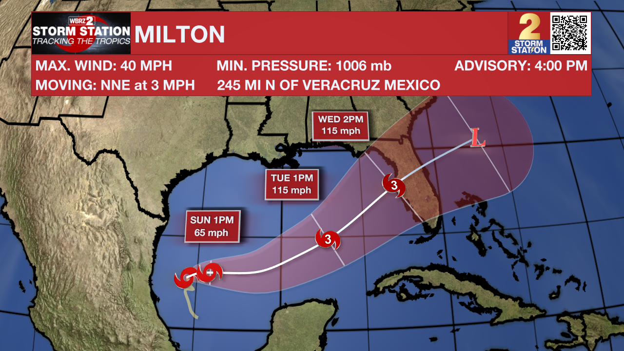
Tropical Storm Milton is churning in the southwestern Gulf of Mexico, and will impact Florida by the middle of next week. While this is unfortunate for Florida, a cold front passing Monday is shielding Louisiana from this system.
Tonight & Tomorrow: Clouds will thin a bit as we head into the overnight hours. Lows will be in the lower 70's. Another unseasonably warm day is expected Sunday. Highs will get to near 91 degrees under partly sunny skies. Humidity will not be off the scales, but there will be a touch of mugginess. A shower or two cannot be ruled out across the viewing area. The vast majority will stay dry.
Up Next: Big changes are on the way. This will come in the form of a cold front. The front is slated to pass in the evening hours of Monday. The rest of the week will feature much cooler, and drier conditions. Highs will be in the middle 80's, with lows near 60 degrees. Some locations, especially north of Baton Rouge, could dip into the upper 50's some nights. These conditions look to last into next weekend.
Get the latest 7-day forecast and real time weather updates HERE.
Watch live news HERE.
Trending News
The Tropics: Tropical Storm Milton has formed in the southwestern Gulf of Mexico. Thankfully, Louisiana impacts looks very low. Some higher swells and coastal flooding is possible. Milton will approach Florida by the middle of next week as a powerful cat 3 hurricane. Significant impacts are possible. One interesting note is that storms that form in the southwestern Gulf of Mexico rarely make it to Florida.
Major Hurricane Kirk remains a powerful storm with maximum sustained winds of 120mph. Though large swells from this system could reach the United States by Sunday, Kirk is a fish storm with a northwest motion becoming north and then northeast by next week as the storm loses strength and heads for Europe.
Following Kirk is Hurricane Leslie which is holding steady in its intensity. Maximum sustained winds are at 80mph as the storm moves west and then northwest Sunday following Kirk out to sea.
A tropical wave is expected to move off the west coast of Africa on Monday or Tuesday. Some development of this system is possible thereafter while it moves westward or west northwestward across the eastern tropical Atlantic. The system is expected to move near or over the Cabo Verde Islands on Wednesday and Thursday, and interests there should monitor its progress.
– Balin
The Storm Station is here for you, on every platform. Your weather updates can be found on News 2, wbrz.com, and the WBRZ WX App on your Apple or Android device. Follow WBRZ Weather on Facebook and Twitter for even more weather updates while you are on the go.
More News
