

Latest Weather Blog
NEW: National Weather Service confirms additional tornadoes from weekend storms
Additional survey crews assessed damage across southern Louisiana on Tuesday that was left behind by weekend storms. Officials determined that three additional tornadoes tracked through portions of Ascension, St. James, Lafourche, and far northern Terrebonne Parishes. Details on these tornadoes have not yet been released. The Storm Station will continue to monitor for updates.
Storm survey results from today: The survey team was able to confirm 3 tornadoes through portions of Ascension, St. James, Lafourche & far northern Terrebonne Parishes. Analysis & QC will continue tomorrow. Ratings, path lengths/widths, etc will be released once QC is complete.
— NWS New Orleans (@NWSNewOrleans) February 18, 2026
This is in addition to the two tornadoes already confirmed in Amite & Wilkinson Counties.
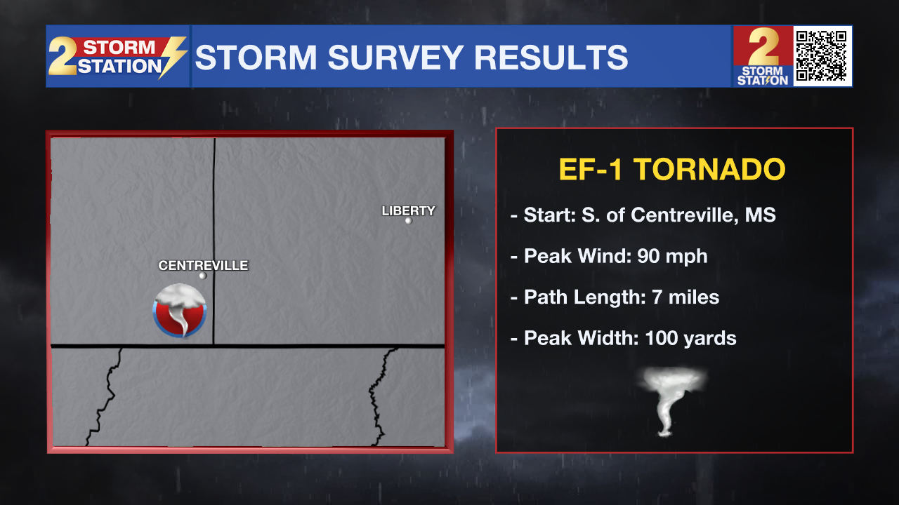
Centreville, MS: EF-1 Tornado
• Estimated Peak Wind: 90 mph
• Path Length: 7 miles
Trending News
• Maximum Path Width: 100 yards
• Start: 6 miles NNW Norwood (Wilkinson County, MS)
• End: 1 mile ESE Centreville (Amite County, MS)
Survey Findings: An EF-1 tornado touched down along Ancil Cox Road on the southwest side of Centerville near Griffin Lane. A few trees were downed, including at least one that brought down a power line. The tornado tracked northeast, roughly paralleling Ancil Cox Road, reaching Old Highway 33. The most significant damage occurred near this intersection, where about a dozen trees were uprooted or snapped, supporting the 90 mph wind rating. Beyond this point, the tornado continued northeast, causing sporadic tree and limb damage. The final accessible point along its path was near Centerville Academy, where minor damage was observed, including a downed light pole, partial roof uplift on a metal building, and a baseball pitching backstop thrown roughly 250?feet into a chain-link fence. The tornado may have continued slightly farther northeast, but confirmation will require further satellite imagery analysis.
Peoria, MS: EF-1 Tornado
• Estimated Peak Wind: 90 mph
• Path Length: 2.3 miles
• Maximum Path Width: 100 yards
• Start: 7 E Liberty (Amite County, MS)
• End: 8 ENE Liberty (Amite County, MS)
Survey Findings: An EF-1 tornado with peak winds of 90 mph touched down along Peoria Road, about 1 mile south of Highway 24. Dozens of trees were snapped and uprooted at the initial damage site. The severity of tree damage suggests the tornado may have first touched down slightly southwest of this location; however, limited access in the rural area prevented confirmation of an extended path. The tornado tracked northeast, crossing Highway 24 and East Fork Road, producing numerous snapped and uprooted trees along this segment. It may have continued beyond the surveyed area, and additional satellite imagery analysis will be conducted to determine the full extent of the path.

Meteorologist Balin Rogers was on-air continuously for several hours on Saturday night, covering multiple Tornado Warnings.
The Storm Station is here for you, on every platform. Your weather updates can be found on News 2, wbrz.com, and the WBRZ WX App on your Apple or Android device. Follow WBRZ Weather on Facebook and X for even more weather updates while you are on the go.
More News
