

Latest Weather Blog
Monday PM Forecast: upper 70s expected ahead of cold front Wednesday
Mild temperatures will last through the middle of the week before our next cold front. An isolated high temperature of 80 degrees is even possible!
Tonight & Tomorrow: A few mid level clouds will pass across skies overnight. As winds continue to shift to an onshore flow, low temperatures will be up compared to previous nights stopping in the low to mid 50s. Added moisture may aid in some nearshore fog as well, but reduced visibility should not be a big problem inland. On Tuesday, the warming trend will continue with high temperatures reaching for the upper 70s. Southeast winds of 5-10mph will add enough moisture that a healthy cloud deck will develop and even a shower or two will be possible with the daytime warming.
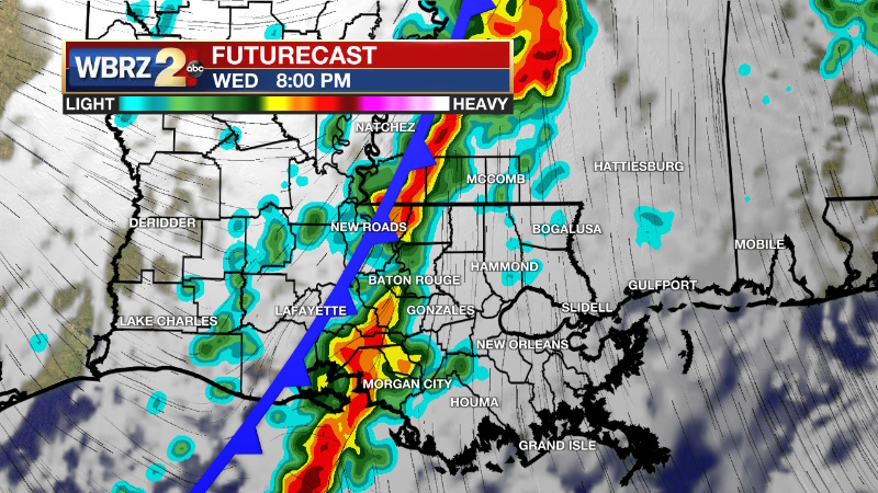
Up Next: After making into the upper 70s, a cold front will approach the area by late Wednesday. A line of showers and thunderstorms is likely during the late afternoon and early evening hours. While the ingredients for severe weather are not overly favorable, there is just enough that one or two could produce gusty wind. The front will push through overnight with gradual clearing on Thursday. This initial front will be sourced from the Pacific Ocean, meaning temperatures will only retreat to average. A reinforcing cold front of Canadian origin will pass by dry on Friday but will deliver much colder temperatures for the weekend. Plan to bundle for Mardi Gras parades next weekend with highs in the 50s and lows in the 30s. It will be dry though.
Trending News
Get the latest 7-day forecast and real time weather updates HERE.
Watch live news HERE.
Detailed Forecast: An upper level ridge will pass over the region through Tuesday. With a surface high over the Mid-Atlantic setting up onshore flow across the area, moisture will slowly build over the central Gulf Coast. Tonight, there will not be enough to cause major problems with fog away the coast. More clouds will develop due to increasing moisture and warm low level temperatures on Wednesday. In fact, there may be just enough instability for a shower or two to develop. If winds are light enough, thicker, visibility reducing fog could more of an issue on Wednesday morning. An upper level trough over the Midwest will help to deepen a surface low pressure system and associated cold front across Texas on Wednesday afternoon. This system will push across the Arklatex region during the evening hours. As the cold front arrives, a band of showers and thunderstorms are anticipated. The parameters for severe weather are on the low side, but not absent. There should be enough moisture and instability but the upper level winds are a little weaker with minimal spin with increasing height in the atmosphere. Therefore, if one or two storms can act up, gusty wind would be the most likely hazard. The front will be east of the area by Thursday afternoon, if not sooner, allowing for clearing skies. Northwest winds will ramp up later Thursday into Friday as a strong surface high moves from the Mountain West to the Midwest. Much colder and drier air will push into the area leading to below average temperatures for the upcoming weekend. The surface high will build overhead Saturday and Sunday leading to clear skies and light winds and a few nights in the 30s this weekend.
--Josh
The Storm Station is here for you, on every platform. Your weather updates can be found on News 2, wbrz.com, and the WBRZ WX App on your Apple or Android device. Follow WBRZ Weather on Facebook and Twitter for even more weather updates while you are on the go.
More News
