

Latest Weather Blog
Monday PM Forecast: Pleasant stretch ahead; tropical mischief targeting the Gulf Coast
A drier pattern takes hold for the rest of the week, bringing warm afternoons and seasonably cool mornings. Rain chances return by the weekend, however, as a tropical troublemaker approaches the northern Gulf Coast.
Tonight & Tomorrow: Any afternoon showers will wind down quickly into the evening. Skies will clear up overnight, dropping temperatures into the low 70s by early morning. Tuesday will bring more sunshine overall, and temperatures will respond. Highs will climb into the upper 80s by mid-afternoon, potentially touching 90° in a few neighborhoods. Rain will become scarce.
Up Next: The rest of the week will follow Tuesday’s pattern closely. Sunshine will dominate, and highs will reach the upper 80s on most days. Though above average for the time of year, the warm days will follow comfortably cool mornings in the mid-to-upper 60s. This is thanks to another shot of less humid air gradually advancing into the area.
Rain chances will start creeping back up late Friday and through the weekend as another wave of tropical moisture rolls in. However, understand that this forecast is not locked in yet since it’s tied to possible tropical development in the Gulf. The exact track will be the deciding factor: a path closer to home means a much wetter weekend, while a track further east would quickly cut off rain chances from west to east. Stay connected as the week unfolds and the picture becomes clearer. See The Tropics section below for the latest on what the Storm Station is watching in the Gulf.

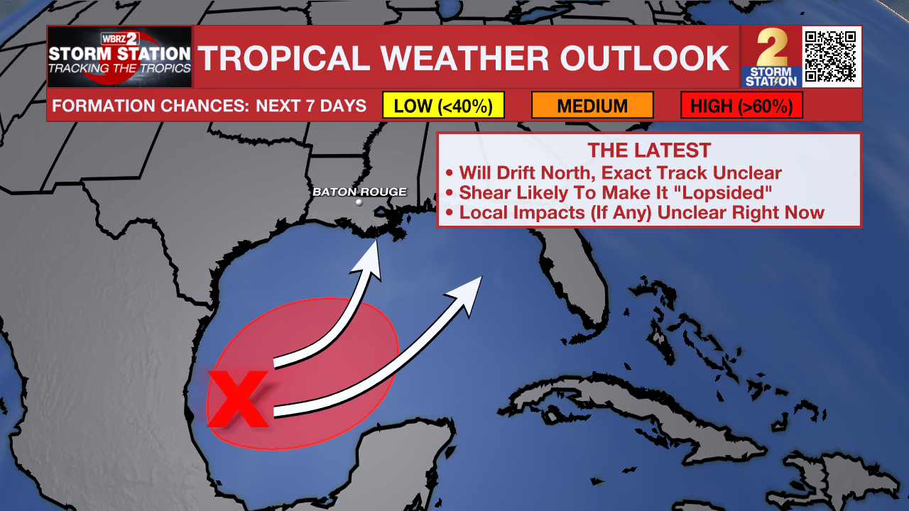
The Tropics: A region of low pressure in the southwest Gulf is producing a disorganized area of showers and thunderstorms. Gradual development of this system appears increasingly likely, and a tropical depression is now expected to form by midweek. The next name on the list is Isaias (ees-as-EE-ahs).
Trending News
This system will eventually turn northward, charting a path toward the U.S. Gulf Coast. Since tropical development has yet to take place, the forecast remains prone to big swings. For that reason, local impacts (if any) are unclear at this time. However, strong wind shear near the coast should work against it, keeping the structure disorganized and capping its intensity. The Storm Station will continue to provide regular updates on the system’s track as the week progresses.
Get the latest 7-day forecast and real-time weather updates HERE.
Watch live news HERE.
— Meteorologist Malcolm Byron
The Storm Station is here for you, on every platform. Your weather updates can be found on News 2, wbrz.com, and the WBRZ WX App on your Apple or Android device. Follow WBRZ Weather on Facebook and X for even more weather updates while you are on the go.
More News

