

Latest Weather Blog
A great shift in the Pacific is likely to impact the upcoming hurricane season
The Pacific Ocean is heating up, and El Niño appears ready to take the driver’s seat as the peak of hurricane season kicks into high gear. If this pattern develops fully, it may pump the brakes on the number and intensity of hurricanes in the Atlantic during the upcoming season.
La Niña Phasing Out, El Niño Building
For the last two hurricane seasons, La Niña has been the dominant force. During La Niñas, strong easterly trade winds push warm surface water toward Asia, allowing cooler water to well up along the South American coast. This reshapes the global atmospheric circulation, effectively weakening the upper-level winds that typically guard the Atlantic. This works in favor of tropical systems. As it turns out, La Niña was one of the key contributors to the active 2024 and 2025 Atlantic hurricane seasons.
Now it appears La Niña's time is up. A massive pool of warm water has been traveling from the West Pacific toward the east over the past couple of months, hiding a few hundred feet beneath the water surface. Now, the warmth is beginning to emerge at the sea surface off the coast of South America.
Water temperatures compared to average along the Equator for the first 1,500 feet beneath the surface. The belt of deeper reds and oranges corresponds to an expansive pocket of warm water migrating toward the East Pacific.
In the coming months, that pool of warm water will continue expanding toward the surface in the East Pacific, swinging the pendulum toward El Niño. Such a transition would trigger a chain reaction that strengthens upper-level winds across the Atlantic — opposite of La Niña. These winds work to shred apart developing tropical cyclones before they get organized. Historically, El Niño years see fewer named storms and, crucially, fewer major hurricanes. Current projections indicate a 80% chance of El Niño by the peak of hurricane season.
Trending News
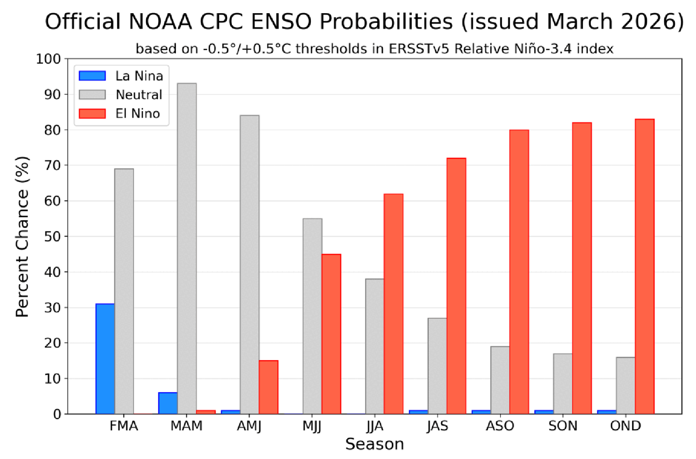
Probabilities of El Niño vs. La Niña by season. 'ASO' describes the probabilities for the August-September-October season, which coincides with the peak of hurricane season.
Still Remain Vigilant
While El Niño is an ally that promotes below-average activity, it isn't a perfect "off" switch. For instance, if the enhanced upper-level winds over the Atlantic take a break and a storm finds a patch of warm water, a hurricane can still quickly spin up.
The timing of the transition to El Niño also matters. There's a gap between the exit of La Niña and the arrival of El Niño that may overlap with the start of hurricane season. Early-season storms in June and July often form before the wind shear “shield” of El Niño takes hold.
Also, remember that it only takes one storm to cause big problems, even during "quieter" peaks in August and September. 1992 was an incredibly quiet year — until Hurricane Andrew hit. That's a sobering reminder that a "slow" year on paper can still be a catastrophic year on the ground.
Most Likely Outcome
The upcoming hurricane season appears likely to be notably quieter than the last few seasons. As El Niño tries to take control, the most probable result is a below-average season. Such seasons tend to feature at least one or two high-end hurricanes, but they often recurve out to sea and avoid the Caribbean/Gulf.
Every now and again, a hurricane can sneak through — rest assured, the Storm Station will be keeping close tabs on any system that threatens. The first official outlook for hurricane season from Colorado State University will be released in April.
The Storm Station is here for you, on every platform. Your weather updates can be found on News 2, wbrz.com, and the WBRZ WX App on your Apple or Android device. Follow WBRZ Weather on Facebook and X for even more weather updates while you are on the go.
More News
