

Latest Weather Blog
Flood Watch issued for all of south Louisiana ahead of heavy rainmaker
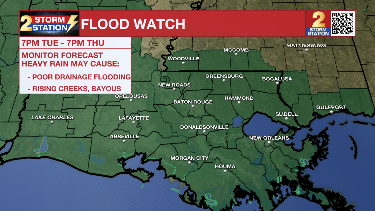
Tonight & Tomorrow: A rapid change will take place on Monday night as a warm front approaches the coast. The all-too-familiar humidity will be felt as early as Tuesday morning. Clouds will increase as well, and some spotty showers will be possible by daybreak. Look for a low in the mid-60s. The warm front will move into the area by afternoon. And copious amounts of moisture present, that will trigger scattered to numerous showers and thunderstorms. Rain chances will climb even higher after dark as an organized complex of thunderstorms moves through. Just about everyone will see rain on Tuesday night. Rain rates will be intense at times, and storms should eventually reorient in a fashion that would lead to training, or repeating, thunderstorms. Flash flooding is a concern. A Flood Watch will go into effect on Tuesday evening ahead of this round. Severe weather is not off the table either. Gusty winds and isolated tornadoes are the primary concerns starting Tuesday afternoon, lasting through the evening.
Up Next: Tuesday night's storminess will set the stage what what happens thereafter. That means there are some unknowns in terms of exact timing and coverage on Wednesday. Regardless, leftover moisture and additional disturbances will keep rain chances elevated. The same goes for Thursday. Any extra rain would aggravate the flash flood risk further. All told, 3-6” of rain with locally higher amounts appears likely in the next week. Most of that will fall through Thursday. Moisture will begin exiting around Mother’s Day Weekend. While a spotty shower cannot be ruled out, the upcoming weekend appears relatively drier.
River Flooding: The National Weather Service has issued a RIVER FLOOD WARNING for the Mississippi River at Red River Landing, Baton Rouge, Donaldsonville, and Reserve, as well as the Atchafalaya River at Morgan City. This flooding is due to runoff from flooding rains up north a few weeks ago, and is separate from heavy rain caused by local weather patterns.
• At Red River Landing, flood stage is at 48 feet. The river has already crested at 59.5 feet. The river remains in moderate flood stage with levels falling. At current levels, Angola farmland on the left bank becomes inundated. All river islands along the reach from Red River Landing to Baton Rouge will remain inundated with recreational camps and river bottom farmland under water. This gauge will fall below flood stage around May 21.
• At Baton Rouge, flood stage is 35 feet. The river has already crested at 42.2 feet. The river remains in major flood stage with levels slowly falling. At current levels, the grounds of the older part of Louisiana State University's campus become soggy. This includes the area around the Veterinary Medicine building, the Veterinary Medicine Annex, and Alex Box Stadium. Levees protect the city of Baton Rouge and the main LSU campus at this level. Caution is urged when walking near riverbanks. This gauge will fall below flood stage around May 14.

• At Donaldsonville, the flood stage is at 27 feet. The river has already crested at 30.9 feet. The river remains in moderate flood stage with levels slowly falling. At current levels, navigation becomes difficult for smaller river craft. Safety precautions for river traffic are urged. This gauge will fall below flood stage around May 12.
• At Reserve, flood stage is at 22 feet. The river has already crested at around 23.7 feet. The river remains shy of moderate flood stage with levels slowly falling. At current levels, marine and industrial interests along the river, upstream barge operators, and facilities are impacted. Navigation will become difficult for smaller river craft. This gauge will fall below flood stage around May 9.
• At Morgan City, flood stage is at 6 feet. The river has already crested at around 6.7 feet. The river remains in minor flood stage with levels slowly falling. At current levels, the city dock will be under water. Water will cover the lower end of Belleview Front Street in Berwick. Vessel traffic will be affected by stronger river currents. Vessel traffic safety rules will be strictly enforced by the U.S. Coast Guard. The river will fall below flood stage around May 9.
-- The Storm Station Meteorologists
More News
