

Latest Weather Blog
Mild finish to the week, cold rain and possible ice with weekend winter storm
Expect fewer showers and mild temperatures for the rest of the week. A large winter storm will send cold rain to the Capital Area over the weekend, possibly bringing ice to some.
Tonight, Tomorrow & Friday: Afternoon showers will gradually taper in coverage through the evening. Still, spotty showers will linger overnight under mostly cloudy skies. Lows will be mild, only dipping into the mid-50s. Rain will be harder to find on Thursday. Highs will respond by jumping into the low 70s. While an occasional light shower isn’t out of the question, there will be more dry time. Don’t be surprised if caught by a stray shower on Friday either. Expect another warm afternoon on Friday, but with the arrival of a cold front, highs will vary. Baton Rouge has the potential to reach the upper 60s, with 70s more likely by the coast, and lower 60s closer to Mississippi. This front will set the stage for some nasty weather over the weekend.
Winter Storm Potential: A large winter storm will track across the Southern United States into the weekend, producing large swaths of snow, ice, and rain. The Baton Rouge Metro Area will find itself very close to the southern extent of ice — a little too close for comfort. Nailing the high temperature on Saturday will be tricky, as warmer air will be drawn inland by a storm system. That should keep temperatures warm enough to support periods of chilly rain through most of the daytime hours on Saturday.
.png)
Periods of rain will continue Saturday night into Sunday. Meanwhile, northwest winds will drive the freezing line closer to the Capital Area. If the temperature drops below 32°, plain rain would transition to freezing rain. That could happen at any point Saturday night or Sunday. The greatest risk of accumulating ice will be along and north of a line from New Roads to McComb. By the I-10/12 corridor, the risk is lower, and that trend continues to the south and east. However, even if precipitation wraps up before temperatures inevitably drop below freezing later Sunday, any wet surfaces could freeze — especially bridges and overpasses.
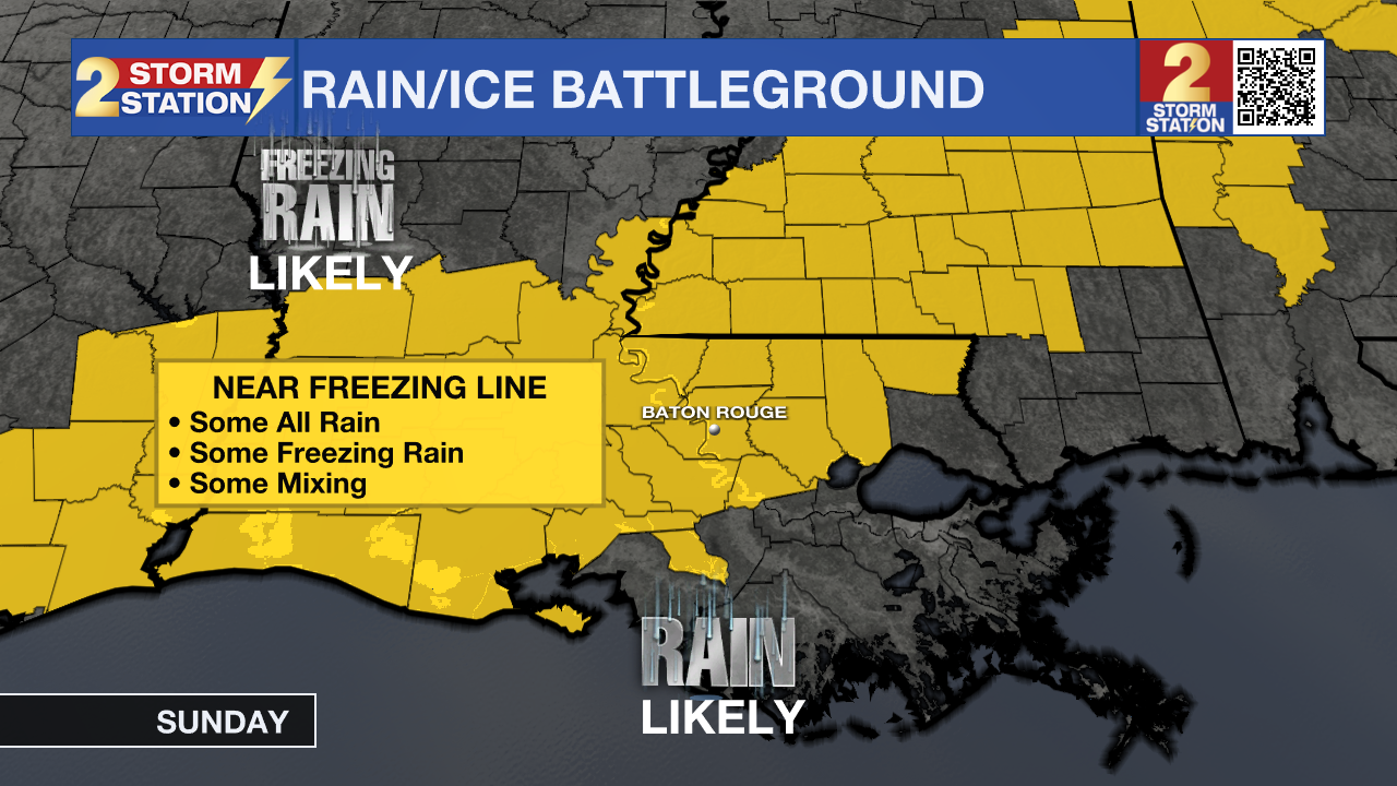
A minor change from just 32° to 33° makes a major difference in impacts for an event like this, so monitor Storm Station forecasts as new information comes in each day. Be prepared to change or cancel travel plans this weekend.
Trending News
Up Next: Precipitation will clear out late Sunday, but the cold will tighten its grip. A hard freeze looks likely both Monday and Tuesday morning with lows in the low to mid-20s for several hours. Use any dry time later this week to wrap exposed, outdoor pipes if you have not already done so this season. Both afternoons will show some sun and get highs into the 40s.
Get the latest 7-day forecast and real-time weather updates HERE.
Watch live news HERE.
— Meteorologist Malcolm Byron
The Storm Station is here for you, on every platform. Your weather updates can be found on News 2, wbrz.com, and the WBRZ WX App on your Apple or Android device. Follow WBRZ Weather on Facebook and X for even more weather updates while you are on the go.
More News
