

Latest Weather Blog
Friday evening video forecast
Related Story
The Storm Station has been tracking a significant Arctic outbreak heading toward the Gulf Coast, and it’s shaping up to be even colder than the chill felt last weekend. A powerful cold front will move through the region and bring dangerously low temperatures and biting winds that will stick around through Sunday. While no precipitation is expected with this system, the "dry cold" should still be taken seriously—temperatures on Saturday will struggle to even climb above the freezing mark.
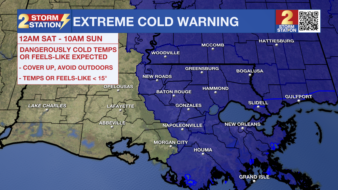
An EXTREME COLD WARNING will be in effect Saturday night through Sunday morning for all of southeast Louisiana and southwest Mississippi. Dangerously cold wind chills as low as 10°F are expected. Frostbite and hypothermia will occur if unprotected skin is exposed to these temperatures. An extended period of freezing temperatures could cause ruptured water pipes.
HOW WIND CHILL WORKS - INSIDE THE WEATHER WITH WBRZ CHIEF METEOROLOGIST, DR. JOSH EACHUS
Dress in layers, including a hat, face mask, and gloves if you must go outside. To prevent water pipes from freezing, wrap or drain them or allow them to drip slowly. Keep pets indoors as much as possible. Make sure outdoor animals have a warm, dry shelter, food, and unfrozen water. Make frequent checks on older family, friends, and neighbors. Ensure portable heaters are used correctly. Do not use generators or grills inside. If you do not have heat in your home or lack shelter, you can call 211 for assistance locating appropriate shelter from the cold. Use caution while traveling outside. Wear appropriate clothing, a hat, and gloves.
Tonight & Tomorrow: The real impactful cold will set in tonight as the winds increase. North winds of 10-20mph will make it feel much colder than what the thermometer shows. By Saturday morning, low temperatures will be in the upper 20s, and wind chills could drop into the single digits, especially for those north of the I-10/I-12 corridor. In general, skies will clear. After all clouds exit through the morning, Saturday will feature plenty of blue sky and sun. Don’t be fooled, though. Even during the afternoon, it will likely feel like it's below freezing as the winds continue and highs only climb into the upper 30s.

Up Next: Temperatures won’t stay in the deep freezer too much longer. After another hard freeze—albeit with lighter winds—on Monday morning, sunshine will push afternoon temperatures close to 60 degrees. Tuesday may actually begin above freezing before warming into the 60s. Clouds will thicken through the day as the next cold front is set to spread some showers across the region on Wednesday. Temperatures will fall back again after the front, but they do not look as cold as the last two blasts.
Get the latest 7-day forecast and real-time weather updates HERE.
Watch live news HERE.
– Josh
The Storm Station is here for you, on every platform. Your weather updates can be found on News 2, wbrz.com, and the WBRZ WX App on your Apple or Android device. Follow WBRZ Weather on Facebook and X for even more weather updates while you are on the go.
News
