

Latest Weather Blog
Wednesday PM Forecast: new timeline on late week front
The Storm Station is tracking a cold front set to arrive just before the weekend begins. A new timeline is something to take note of if you have Friday evening plans.
Tonight & Tomorrow: A few clouds early may give way to some patchy fog late. Where south winds remain above 5-10mph, it will be hard for fog to thicken much. Low temperatures will make it into the low 60s. The warming trend will continue on Thursday adding approximately another 5 degrees. High temperatures will be in the mid 80s. Skies will be mostly sunny and the south breeze will pick up to 10-15mph.
Up Next: Friday will begin muggy in the upper 60s followed by another high in the mid 80s. After some early sun, clouds will increase through the day. During the evening hours, a frontal system will push into the area with a round of showers and thunderstorms. The timeline has changed, and the arrival time appears much later, largely after midnight and before dawn Saturday. At this time, the most favorable ingredients for severe weather look to set up well north of I-12 and there is a 3/5 “Enhanced Risk” for areas north and west of Baton Rouge. There is a 2/5 “Slight Risk” for the Metro Area. Given the ingredients available, gusty wind would be the primary threat if any thunderstorms turn severe. On the other side of the front, very little change in temperatures is expected, with thermometers and humidity barely lower for the beginning of the weekend. The chance for showers and thunderstorms will return Sunday and last through at least Monday.
Get the latest 7-day forecast and real time weather updates HERE.
Watch live news HERE.
Trending News
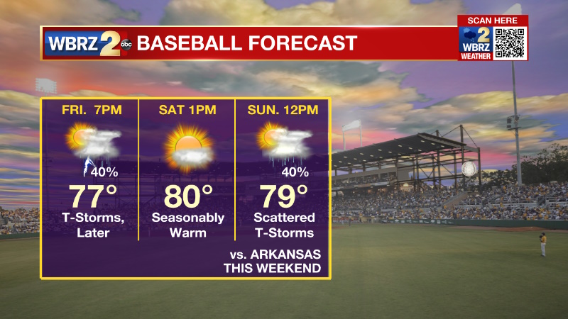
LSU Baseball: The weekend series against Arkansas and opening of SEC Baseball at Alex Box Stadium looks tenuous. Prospects for the Friday evening game finishing look better than before, but are far from a certainty. Scattered showers and thunderstorms are still a possibility on Friday evening as temperatures hang in the upper 70s. The Saturday afternoon game is the pick of the weekend in terms of weather. Beneath mostly sunny skies, highs will chug into the low 80s. You will need sunscreen. For the capper, showers and thunderstorms could be a problem as well. There will be increasing chances for rain through Sunday afternoon.
--Josh
The Storm Station is here for you, on every platform. Your weather updates can be found on News 2, wbrz.com, and the WBRZ WX App on your Apple or Android device. Follow WBRZ Weather on Facebook and Twitter for even more weather updates while you are on the go.
More News
