

Latest Weather Blog
Wednesday PM Forecast: dry air arrives, cool air lags behind
Clear skies and drier air will settle across the Capital Area. Another weak cold front will push cooler air into the region this weekend, but chances for any rain remain slim.
Clear & Crisp: Thursday into Friday
Reinforcing Cool Air: Arriving for a cooler weekend
Uncertainty Next Week: possibility of passing clouds and showers

Trending News
Tonight and Tomorrow: As today's weak cold front finishes sweeping offshore, all clear skies will continue overnight. Thanks to drier air, lows will be able to dip to seasonable levels in the low to mid 50s. You may want a light layer for the bus stop or morning walk. A ridge of high pressure will settle directly over the Capital Area, squashing clouds and any chance of rain. By Thursday afternoon, abundant sunshine will warm highs into the low 80s.
Up Next: Another weak cold front will slip through on Friday, bringing a slight increase in passing clouds and an outside shot at a spotty shower, mainly south of I-10. After another high in the low 80s, much cooler air will arrive overnight into the weekend.
After waking up to lows in the low 50s on Saturday morning, afternoon highs will struggle to reach the mid 70s with a mix of sun and clouds. If you are heading out to LSU or Southern for the tailgates and games, take some layers, especially for the morning and evening. Saturday night lows will tumble down into the upper 40s across Baton Rouge, with communities north of I-10 falling into the mid-40s. Sunday will then be the coolest day of the extended forecast, with afternoon highs staying in the upper 60s with more clouds than sun.
There is uncertainty about the forecast for next week. One possible scenario is that a weak storm system will cross the region with passing clouds and showers. A second possible scenario is that the storm system gets held up to the west and weakens with minimal noticeable change for the Capital Area. Details on which scenario will prevail should come into focus by the weekend.
Get the latest 7-day forecast and real-time weather updates HERE.
Watch live news HERE.
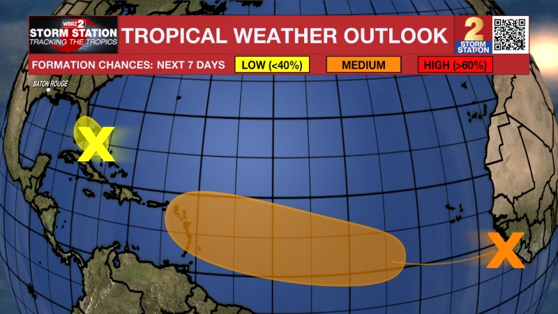
The Tropics: The Gulf and Caribbean will remain quiet. Out in the open western and central Atlantic, a broad, non-tropical low several hundred miles south of Bermuda has a medium chance of developing subtropical characteristics as it drifts eastward across the open ocean over the coming days. It will stay far out at sea and will pose zero threat to the United States.
– Josh
The Storm Station is here for you, on every platform. Your weather updates can be found on News 2, wbrz.com, and the WBRZ WX App on your Apple or Android device. Follow WBRZ Weather on Facebook and X for even more weather updates while you are on the go.
More News

