

Latest Weather Blog
Wednesday AM Forecast: Cold front has pushed through, cooler air filtering in
A much colder, drier air mass has settled in, bringing mainly clear skies and crisp conditions through the end of the workweek. Highs will top out in the 60s, with lows in the 30s the next few days!
.png)
Today & Tonight: Expect a bright, mainly sunny day with some thin high clouds overhead. Even though a colder air mass is moving in from the north, afternoon highs should still reach near-normal levels in the upper 60s thanks to full sunshine and low humidity. Winds will be breezy at times, out of the north at 10-15 mph. Temperatures will tumble quickly after sunset under clear skies and calming winds. Overnight lows will drop into the upper 30s to lower 40s. A chilly, crisp night is ahead.
Up Next: Thursday and Friday will be the coolest days of the week as the core of this colder air settles in. Highs will only reach the upper 50s to lower 60s—about 5 to 10 degrees below average. Lows will dip into the low to mid-30s Friday morning, with the lower 40s closer to the coast. Widespread frost is likely, which could kill sensitive plants if not covered or moved inside.
Trending News
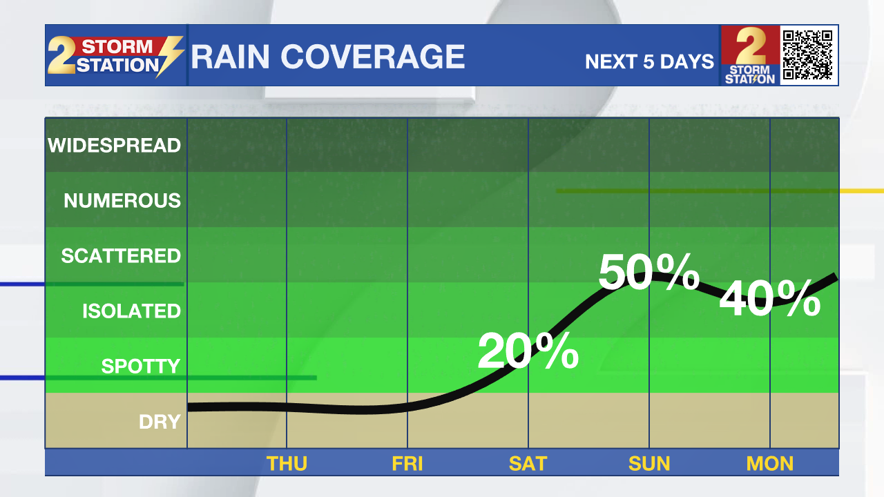
By Saturday, winds shift from the south, pulling in moisture ahead of a strong system moving in from the west. Clouds will thicken through the day, and by Saturday night, humidity and moisture levels surge. Rain becomes likely on Sunday, with periods of heavy rainfall possible and a few thunderstorms. Totals could reach 2–3 inches in isolated spots—welcome rain given the recent dryness. Highs this weekend will reach the upper 60s to low 70s, with Saturday night staying mild thanks to the moisture.
Another disturbance approaches Monday into Tuesday, keeping rain chances elevated. Beyond that, the biggest uncertainty is temperature: some models push a backdoor front through the region early next week, while others keep it north. Depending on which scenario plays out, temperatures could end up well below normal—or much warmer. For now, the more middle-ground guidance is being used until confidence improves.
The Tropics: For the Gulf, Caribbean, and Atlantic, all is quiet. No new tropical development is expected over the next seven days.
Get the latest 7-day forecast and real-time weather updates HERE.
Watch live news HERE.
– Balin
The Storm Station is here for you, on every platform. Your weather updates can be found on News 2, wbrz.com, and the WBRZ WX App on your Apple or Android device. Follow WBRZ Weather on Facebook and X for even more weather updates while you are on the go.
More News
