

Latest Weather Blog
Tuesday AM Forecast: Dense fog this morning, "cool" front by end of week
Visibilities this morning will be low for some due to dense fog, so make sure to stay on alert when driving. Although it is currently very humid, a "cool" front will drastically lower humidity by the end of the week.
Today & Tonight: Some locations have observed visibilities less than a quarter of a mile this morning. That is why a dense fog advisory has been issued for most of the area. Conditions will improve by around 8-9am, with the rest of the day being hot and humid. Temperature will reach near 90 degrees under partly sunny skies. Storms will pop in the afternoon and evening, but coverage will remain isolated in nature. Overnight, lows will settle near 71 degrees, with fog once again possible.
Up Next: Wednesday will keep its summer feel with heat and humidity still in place, but that pattern is about to change. A cold front pushing through Wednesday night will bring a noticeable shift for the rest of the week. Afternoon highs will only dip slightly, staying in the mid to upper 80s — typical for early October. However, the mornings will feel different as lows slide into the 60s, with humidity steadily easing. By the weekend, many spots will start the day in the low 60s under clear, comfortable skies. Sunshine and drier air will make for an nice weekend of fall weather.
The Tropics:
Trending News
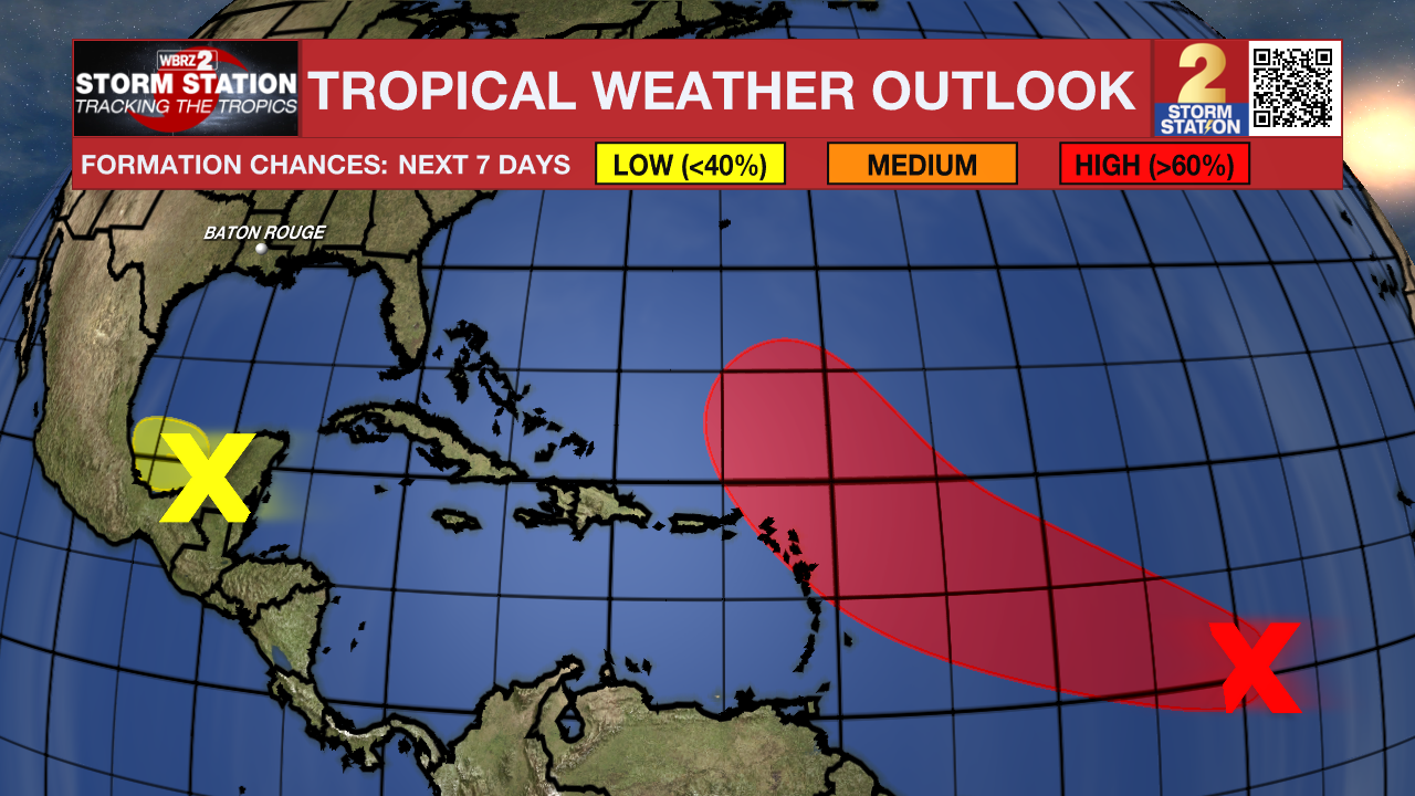
Central Tropical Atlantic:
Satellite-derived wind data indicate an area of low pressure located
about 1500 miles east of the Windward Islands is becoming better
defined. The associated shower and thunderstorm activity is showing
signs of organization, and environmental conditions appear favorable
for continued development of this system. A tropical depression or
storm is likely to form in the next day or so while it moves quickly
west-northwestward across the central tropical Atlantic. This system
is expected to be near or north of the northern Leeward Islands on
Thursday and Friday, and interests there should continue to monitor
its progress.
Southwestern Gulf:
A trough of low pressure located near the Yucatan Peninsula is
producing a large area of disorganized showers and thunderstorms
over portions of northern Guatemala, southeastern Mexico, and the
adjacent waters of the southwestern Gulf. This system is expected
to emerge over the Bay of Campeche later today, and some slow
development is possible before it moves inland by the middle of the
week. Regardless of development, areas of heavy rain and gusty winds
are likely across portions of the Yucatan Peninsula, Belize, and
southern Mexico during the next few days.
Get the latest 7-day forecast and real-time weather updates HERE.
Watch live news HERE.
— Balin
The Storm Station is here for you, on every platform. Your weather updates can be found on News 2, wbrz.com, and the WBRZ WX App on your Apple or Android device. Follow WBRZ Weather on Facebook and X for even more weather updates while you are on the go.
More News
