

Latest Weather Blog
Thursday PM Forecast: warm weekend ahead for high school, college football
The Capital Area is well into a warming trend. If you’re a fan of short sleeves and shorts, this forecast is for you, as temperatures will be running above normal well into next week.
Fog Potential: The only notable weather impact through the weekend will be some patchy, dense fog developing, especially during the overnight and early morning hours. This is most likely tonight and tomorrow night. If you commute to work or school around daybreak, please remember to slow down and turn on low-beam headlights if you encounter any thick fog. Visibility can drop quickly, making driving hazardous. Take your time and keep a safe distance from other vehicles!
Tonight & Tomorrow: Clouds will thin out this evening, leading to temperatures settling back into the low to mid 50s once again. Patchy fog will be possible late. Friday will be mostly sunny and warm with highs in the upper 70s, possibly even some lower 80s.
High School Football: The Friday Night Blitz, playoff edition, will bring clear skies and pleasant temperatures. Kickoff temperatures will likely be in the mid-60s, falling toward the upper 50s by the final whistle. You might want to bring a light jacket just in case, but no rain gear is needed!
Trending News
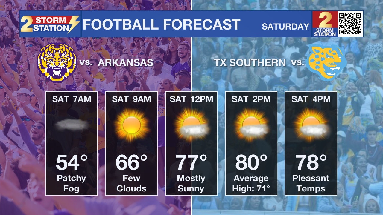
College Football: Tailgaters heading out early before the LSU or Southern homes games can expect patchy fog to quickly clear for mostly sunny skies as temperatures warm out of the 50s into the 60s. For the 11:45 am kickoff of the Tigers game, temperatures will be in the 70s, possibly climbing into the 80s before it is over. That means the Jaguars will kick off in the low 80s around 2 pm with temperatures back into the 70s by the end of the game. Take sunglasses into either stadium!
Up Next: The fantastic weather keeps rolling into the rest of the weekend! Outdoor activities will have mainly clear, dry conditions with highs in the low 80s and lows in the upper 50s. Not only will the warming trend continue next week, but you may start to feel some humidity as well. Monday, Tuesday, and Wednesday will all feature highs reaching the low 80s. Chances of a stray shower remain low in the 10-20% coverage range, because while there will be enough moisture in the atmosphere, there just aren’t going to be any storm systems or fronts to kick out a lot of action.
.png)
The Tropics: For the Gulf, Caribbean, and Atlantic, all is quiet. No new tropical development is expected over the next seven days.
Get the latest 7-day forecast and real-time weather updates HERE.
Watch live news HERE.
– Josh
The Storm Station is here for you, on every platform. Your weather updates can be found on News 2, wbrz.com, and the WBRZ WX App on your Apple or Android device. Follow WBRZ Weather on Facebook and X for even more weather updates while you are on the go.
More News
