

Latest Weather Blog
Thursday PM Forecast: temperatures swings continue as we await next round of rain, storms
The next impact will be a strong cold front pushing rain and thunderstorms through the region on Saturday night. After a warm, windy, somewhat sticky start to the weekend, much cooler air will arrive for the finish.
Tonight and Tomorrow: Partial clearing is expected overnight and low temperatures will dip into the low 40s. Any sunshine seen on Friday will be early. As a warm front lifts north through the region, clouds will increase. Decreasing afternoon sun should put a cap on highs in the low 60s.
Saturday: To start the weekend, expect warm and windy conditions, with temperatures soaring into the low to mid-80s—possibly near record highs. Winds out of the south at 15-25mph will be noticeable, with gusts up to 35 mph at times. Much of the daytime will be dry but quick moving, isolated showers are possible. A strong cold front will push in from the northwest late in the day and overnight, bringing rain and the risk of severe thunderstorms as this happens (see below).
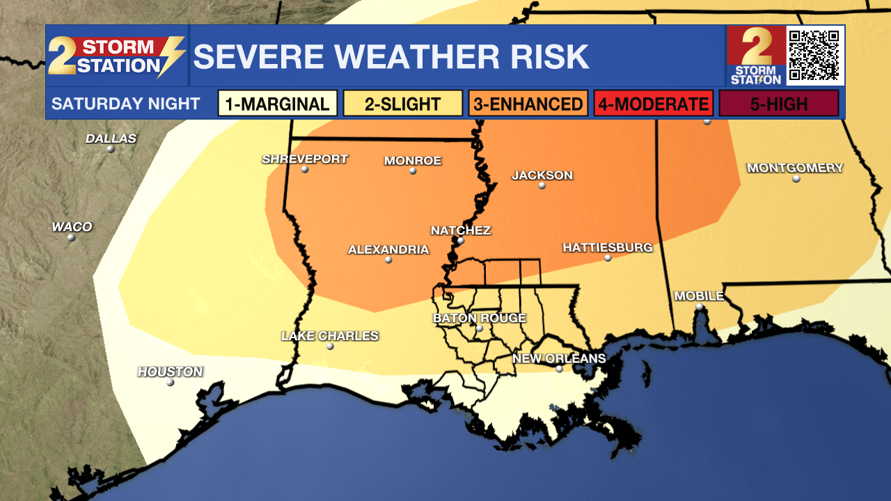
Next Severe Weather Chance – This storm event will likely come down to timing. Current information suggests that the most intense weather, including a line of storms, will move in during the evening and overnight hours.
Trending News
Later at night, upper-level winds will be supportive of strong thunderstorms, but by then, the energy for storms will be decreasing. The best storm energy will be available earlier in the day, but at that point, the upper-level winds won’t be as supportive. If at some point these two factors can overlap, there could be a more favorable window for severe weather.
Given the expected setup, the most likely outcome is a squall line of rain and thunderstorms with damaging wind gusts being the main concern. As for tornado potential, the low-level winds that help create rotation don’t look particularly impressive—just enough to maybe support a brief tornado, especially on the leading edge of the squall line.
The Baton Rouge Area and points south are included in a 2/5 “slight risk” category, while areas near and north of the state line are in a 3/5 “enhanced risk” for severe weather. This indicates the potential for isolated to scattered severe weather events within the risk area.
Sunday & Beyond: On Sunday, the cold front will move out, and a strong push of cold, dry air will settle in, bringing cooler-than-average temperatures. By Monday morning, most areas will be in the 30s, with parts of southwest Mississippi dipping into the upper 20s. As the workweek begins, dry air will maintain cool, clear conditions. However, this setup won’t last long—upper-level steering winds will shift to a more west-to-east pattern on Tuesday, leading to a slight and brief warm-up. On Wednesday, the previous cold front will lift back north over the central Gulf, setting the stage for unsettled weather. Another cold front will move into the southern United States as a storm system forms near the warm front in the Gulf. This combination of features will bring the next chance for rain during the middle of next week. Another shot of cool air may follow this for the end of next week.
Get the latest 7-day forecast and real-time weather updates HERE.
Watch live news HERE.
– Josh
The Storm Station is here for you, on every platform. Your weather updates can be found on News 2, wbrz.com, and the WBRZ WX App on your Apple or Android device. Follow WBRZ Weather on Facebook and X for even more weather updates while you are on the go.
More News
