

Latest Weather Blog
Thursday PM Forecast: enjoy the outdoors through Saturday afternoon, wet pattern looms
The cool and crisp conditions will stick around through Friday. A storm system will approach on Saturday, leading to a stretch of unsettled weather into early next week.
Black Friday: sunny, crisp, and cool
Weekend: increasing clouds leading to steady rain
Next week: still gloomy, likely chilly
Tonight & Tomorrow: Clear skies and light winds will set the stage for a chilly night. Low temperatures will drop into the mid-30s around dawn, and some patchy frost will be possible, especially north and east of Baton Rouge. If you have sensitive plants, consider covering them or moving them inside. Friday will remain crisp and mainly clear. High temperatures will claw back into the low 60s.
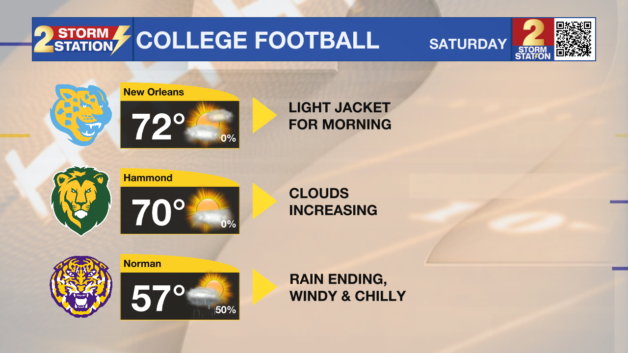
Football Forecasts: Friday night high school football around the Capital Area will enjoy perfect conditions—mainly clear skies, light winds, and chilly temperatures dipping into the 40s by halftime, so jackets will be a must. Southeastern Louisiana’s playoff game should start dry but will have clouds increasing through the day and possibly a shower before the final whistle. The weather ahead of the indoor Bayou Classic in New Orleans on Saturday will be mild and dry, but clouds will increase through the day with a small chance of showers driving home after the game. LSU’s road trip to Oklahoma will likely encounter damp and chilly conditions with early-day rain and temperatures falling from the 50s to the 40s through the afternoon.
Trending News

Up Next: On Saturday, the weather pattern will start to change quickly as winds turn southerly and bring moisture into the atmosphere. Increasing clouds and even isolated, light showers will be possible by evening, though the day certainly won’t be a washout with only 30% rain coverage. Expect morning lows in the mid-40s with afternoon highs in the upper 60s. More inclement weather will arrive overnight into Sunday. A strong upper-level disturbance will roll across the Gulf South, pulling in unusually high moisture levels for late November. Expect a gray, rainy day with widespread showers, periods of heavy rain, and even a few rumbles of thunder. By the end of the weekend, some areas could pick up 1–2 inches of beneficial rainfall.

A relative lull—though perhaps not a full shutdown—in the showers is expected Sunday evening into Monday morning. A front is expected to make it to the coast, bringing another hit of chilly air and continued unsettled weather. The next round of rain is anticipated late Monday into Tuesday. This will be a particularly uncomfortable period outside as it will be wet with temperatures in the 50s and even 40s. Yet another cold front will swipe the moisture out on Tuesday, with clearer and chillier conditions left behind for the middle of the week.
The Tropics: For the Gulf, Caribbean, and Atlantic, all is quiet. No new tropical development is expected over the next seven days.
Get the latest 7-day forecast and real-time weather updates HERE.
Watch live news HERE.
– Josh
The Storm Station is here for you, on every platform. Your weather updates can be found on News 2, wbrz.com, and the WBRZ WX App on your Apple or Android device. Follow WBRZ Weather on Facebook and X for even more weather updates while you are on the go.
More News
