

Latest Weather Blog
Sunday PM Forecast: Freeze Watch posted as the coldest air yet edges closer
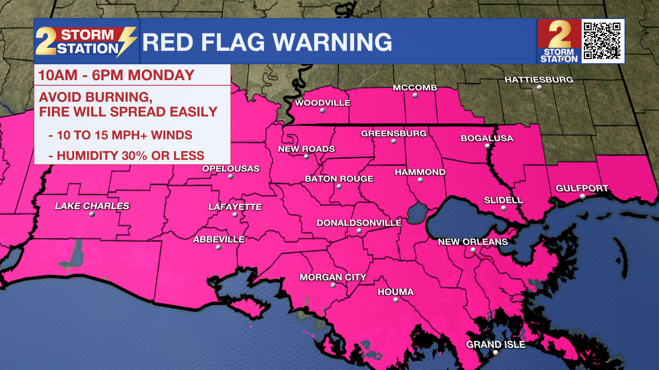
Use remaining time to prepare for the upcoming cold — most will see lows in the 30s starting Monday morning. Take precautions to protect plants, as frost and freeze conditions appear increasingly likely. Ensure pets will have access to warmth and dig out the winter coats. Also, disconnect garden hoses, winterize sprinkler systems, and consider wrapping exposed pipes as a precautionary measure. Another concern on Monday will be the fire weather risk. Gusty winds and dry air could lead to rapid fire spread if any flames ignite, so outdoor burning is not recommended.
Arctic Chill Settling In:
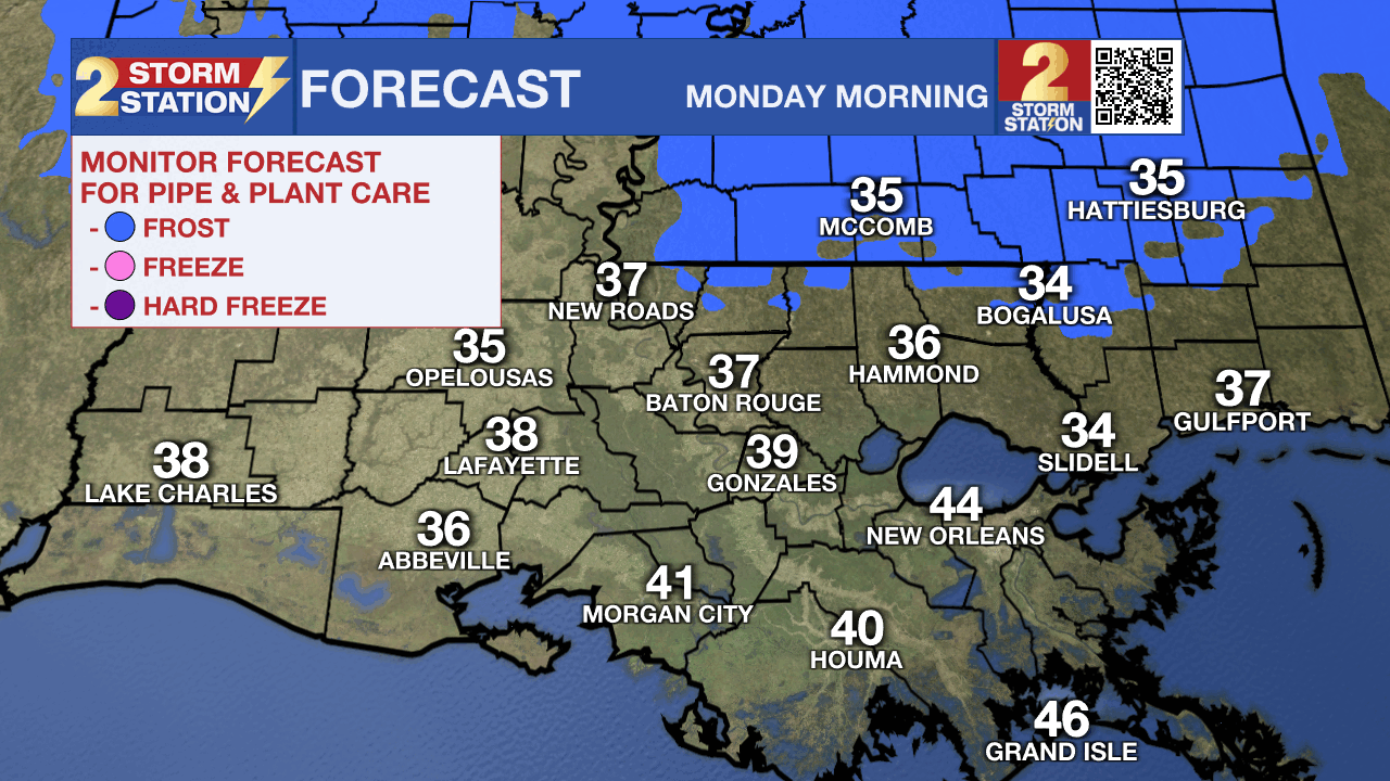
Sunday Night / Early Monday – A north wind at 5-15 mph will drive colder air south through the night, dropping lows into the middle and upper 30s across Metro Baton Rouge. Such temperatures are cold enough to support frost, but the wind will limit that potential to a large extent. On the contrary, the wind will make it feel several degrees colder. Morning wind chills will bottom out near freezing for many — bundle up!
Monday – Even with sunshine, temperatures will struggle to warm. Look for a high temperature near 54° in Baton Rouge, which would rank as the second coolest high temperature for the date. Coats will be needed from start to finish. A stiff north wind gusting to 20 mph at times will add a bite to the air, and combined with very dry air in place, there will be an elevated fire danger. A Red Flag Warning has been issued for all of south Louisiana in addition to far southwestern Mississippi. Any fire that develops will catch and spread quickly. Try to avoid any outdoor burning.
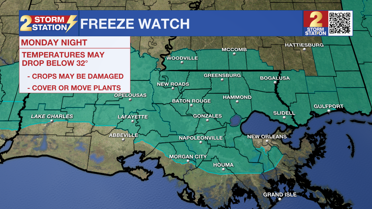
Monday Night / Early Tuesday – A Freeze Watch has been issued for Monday evening through Tuesday morning for most of the Capital Area. Frost and freeze conditions could kill crops, other sensitive vegetation, and possibly damage unprotected outdoor plumbing. This will likely be upgraded to a Freeze Warning in the next day or so.
Trending News
Expect a rapid drop in temperatures once the sun sets. Readings could drop into the 30s as early as the evening, falling below freezing for a couple of hours overnight. A light freeze is expected near and north of I-10/12 at the very least. However, a few neighborhoods, especially in colder river basins, might flirt with the mid-20s; that would be a hard freeze, so consider wrapping exposed outdoor plumbing as a precautionary measure. By the coast, a freeze is still possible, though not everyone will hit 32°. Even so, conditions will favor frost formation.
Rest of the Week: The winter chill won’t last long; temperatures will begin a warming trend on Veterans’ Day. Each day through the rest of the week, a few more degrees will be added to both highs and lows. By the week’s end, highs will be near 80° with lows in the 50s. Early indications point to another frontal passage next weekend. While temperatures won’t tumble as sharply, another round of thunderstorms is likely along with it.

The Tropics: For the Gulf, Caribbean, and Atlantic, all is quiet. No new tropical development is expected over the next seven days.
Get the latest 7-day forecast and real-time weather updates HERE.
Watch live news HERE.
— Meteorologist Malcolm Byron
The Storm Station is here for you, on every platform. Your weather updates can be found on News 2, wbrz.com, and the WBRZ WX App on your Apple or Android device. Follow WBRZ Weather on Facebook and X for even more weather updates while you are on the go.
More News
