

Latest Weather Blog
Saturday PM Forecast: Only a few stray showers today, better rain chances next week
Rain will be hard to come by today, with only spotty activity expected across the area. As available moisture increases next week, so will our chances for beneficial rain.
Today & Tonight: If your plans include tailgating or catching the LSU game on Saturday, be ready for another hot one. Highs will climb into the low 90s under partly sunny skies, and—just like last weekend—sunscreen, plenty of water, and shade breaks will go a long way. Only about a 20% chance of rain is in the forecast, so a brief shower can’t be ruled out, but most will stay dry. Some humidity will stick around into kickoff and beyond, with temps easing from the 90s into the low 80s by evening. Overnight, look for a few clouds and lows near 70.
Up Next: The weather holds steady into Sunday, with partly sunny skies and highs in the low 90s. While a stray shower is possible, most outdoor plans should go off without a hitch. Monday marks the official start of fall, and the atmosphere will start to show some changes too. A series of upper-level disturbances will bring better rain chances through midweek, with about 30–50% coverage each day. Most spots should see at least one round of showers or storms during that period. Thanks to the added clouds and rain, highs will ease back into the upper 80s—much closer to average for this time of year.
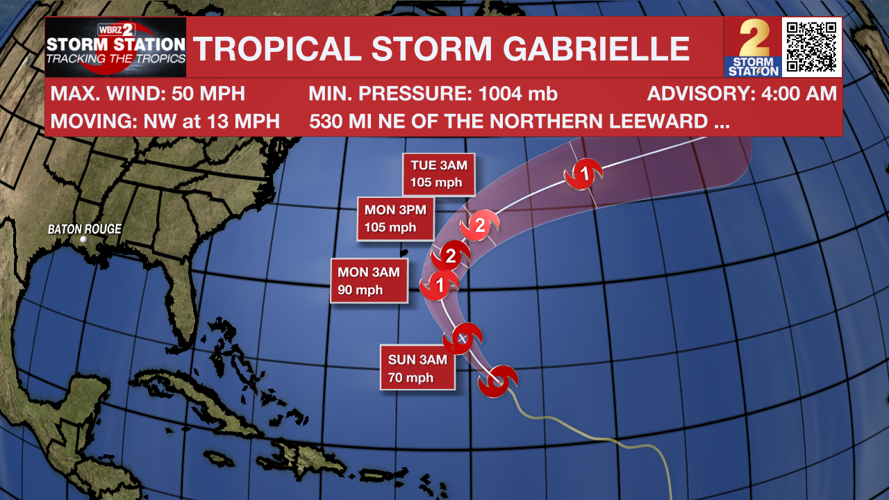
The Tropics: Gabrielle remains a tropical storm with winds around 50 mph, though most of the stronger winds are on its eastern side. The storm is being pushed northwest by high pressure in the Atlantic and is expected to curve north and then northeast over the next few days, staying well east of Bermuda late Sunday into Monday. By midweek, it will get caught in faster-moving winds higher up in the atmosphere, shifting its track a bit farther south than earlier forecasts. Conditions should become more favorable for strengthening soon, and some models suggest Gabrielle could become a strong hurricane within a couple of days. For now, the forecast calls for it to peak as a Category 2 hurricane before slowly weakening later in the week, though it should remain a tropical system through at least the next five days.
Trending News
A tropical wave over the eastern Atlantic is producing disorganized shower and thunderstorm activity well southwest of the Cabo Verde Islands. Some slow development of this system is possible through the middle to latter part of next week while it moves west-northwestward across the eastern and central tropical Atlantic.
Get the latest 7-day forecast and real-time weather updates HERE.
Watch live news HERE.
– Balin
The Storm Station is here for you, on every platform. Your weather updates can be found on News 2, wbrz.com, and the WBRZ WX App on your Apple or Android device. Follow WBRZ Weather on Facebook and X for even more weather updates while you are on the go.
More News
