

Latest Weather Blog
Saturday AM forecast: Dense fog early as warm weather continues
Unseasonably warm and humid weather continues to close out the weekend, but travel concerns remain due to fog. A strong cold front late Sunday night will bring rain, thunderstorms, and a sharp plunge into winter-like cold.
.png)
Today and tonight: Saturday starts with areas of dense fog. A Dense Fog Advisory is in effect, with visibility dropping to a quarter mile or less at times. Fog should gradually improve by mid to late morning as mixing increases, but lingering low clouds may hang around longer in some areas. Once the fog lifts, conditions turn warm, humid, and dry. Afternoon highs climb into the mid to upper 70s, with a few inland spots pushing close to 80 degrees—well above normal for late December. Winds stay generally light from the south, continuing to pull Gulf moisture inland. Saturday night brings another round of fog. While winds may prevent fog from becoming truly widespread everywhere, localized dense fog is likely, especially south of I-10 and near lakes, bays, and rivers.

Use the slider to advance through the next 24 hours of Futurecast
Trending News
Up Next: Sunday looks much like Saturday—warm, humid, and fog-prone, especially during the morning hours. Afternoon highs again reach the upper 70s to near 80. A cold front arrives late Sunday night into early Monday, bringing a change in the weather pattern. Showers and a few thunderstorms will develop as the front moves through. While severe weather is not expected, some storms could produce gusty winds and lightning, especially late Sunday night into early Monday morning. Rain totals should stay under one inch for most locations. Behind the front, winds turn north and strengthen, ushering in cold air. Monday will feel noticeably colder, with temperatures struggling to rise out of the 40s and 50s, especially with brisk winds.
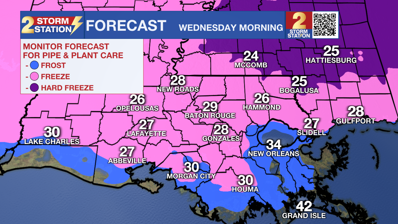
What to look out for: The coldest air of the holiday season arrives Tuesday and Wednesday mornings. Temperatures are expected to fall to near or below freezing across much of the area, with the coldest readings likely north of I-10/12. Wind chills may be a concern on Tuesday. Cold Weather Advisories may be needed, and preparations for sensitive plants, pets, and exposed pipes will be necessary. By midweek, skies remain dry as high pressure settles in. Gradual warming begins late week, but mornings will remain cold through at least Thursday.
Get the latest 7-day forecast and real-time weather updates HERE.
Watch live news HERE.
– Dave
The Storm Station is here for you, on every platform. Your weather updates can be found on News 2, wbrz.com, and the WBRZ WX App on your Apple or Android device. Follow WBRZ Weather on Facebook and X for even more weather updates while you are on the go.
More News
