

Latest Weather Blog
Monday PM Forecast: Pendulum about to swing from hot to stormy pattern again
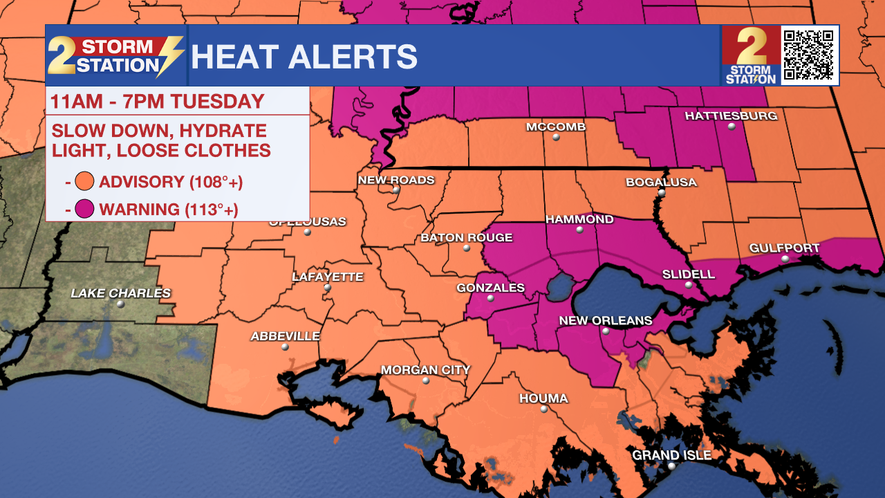
An Extreme Heat Warning will be in effect from 11 a.m. to 7 p.m. Tuesday for Ascension, Livingston, St. James, and southern Tangipahoa Parishes. These areas are generally closer to bodies of water such as lakes and bayous, which will add more humidity to the air. It is in these locations where the heat index could surpass the warning criteria of 113°. A Heat Advisory will be in effect elsewhere, with the heat index peaking near 110°. Such a mixture of heat and humidity could lead to heat-related illnesses, especially without proper hydration. These alerts serve as a reminder to drink plenty of fluids and take it easy during the hottest parts of the day.
Tonight & Tomorrow: A typical late-July night is expected with mainly clear skies and temperatures settling in the mid 70s. Morning sunshine and a persistent ridge of high pressure will launch temperatures into the middle and upper 90s by afternoon — several degrees above average. Paired with humidity, feels-like temperatures will sit above 100° from late morning through early evening, peaking around 110-115° in some neighborhoods. That warrants another round of heat alerts (see above). While heat remains the dominant focus for much of Tuesday, a shift toward a wetter pattern will begin late. Another push of tropical moisture will spark a collection of spotty storms by late afternoon and early evening. A continued influx of moisture overnight will sustain an isolated storm chance after dark, despite the usual trend of storms collapsing at night during the summer.
Up Next: Moisture will not be in short supply by Wednesday. A piece of upper-level energy acting on rich tropical moisture will set the stage for numerous showers and thunderstorms. While not a washout, occasional storms will make carrying an umbrella a wise move. The latest data seem to indicate spotty morning activity followed by a more robust round of afternoon action. Lingering moisture will support additional rounds of storms through Saturday.
During this timeframe, rain will hold back temperatures. Even on days where a delay in storms results in a hot early afternoon period, eventual downpours would provide some relief. Roughly 1-3” of rain is expected through the next week — manageable for the most part, with only a few trouble spots experiencing street and poor drainage flooding. By late weekend and early next week, a weak cool front may stall near or north of the region. Its main impact would be to push the heart of the tropical moisture south, reducing rain chances in the Metro Area.
The Tropics: No tropical development is expected in the next seven days across the North Atlantic, Caribbean Sea, and Gulf.
Trending News
Get the latest 7-day forecast and real-time weather updates HERE.
Watch live news HERE.
— Meteorologist Malcolm Byron
The Storm Station is here for you, on every platform. Your weather updates can be found on News 2, wbrz.com, and the WBRZ WX App on your Apple or Android device. Follow WBRZ Weather on Facebook and X for even more weather updates while you are on the go.
More News
