

Latest Weather Blog
Monday AM forecast: Warm Monday with dense fog early
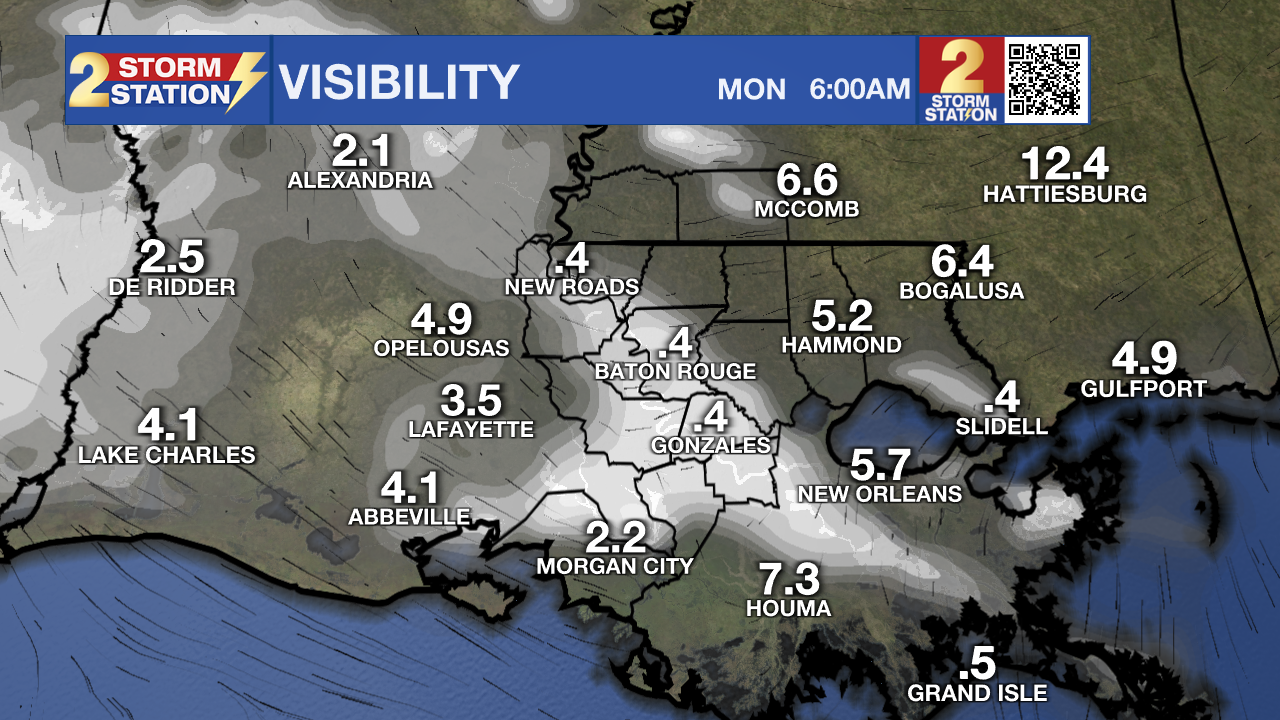
Another warm and quiet day is expected across the Capital Region with temperatures running well above mid-November normals. Patchy fog will once again be an early-morning issue, before sunshine takes over this afternoon. A warming trend continues into midweek, bringing Baton Rouge close to record highs.
Today and tonight: After a very foggy morning, high pressure remains anchored just east of Louisiana, keeping the area warm and stable. Subsidence continues to prevent rain and allow for above-normal temperatures.
It’ll stay partly sunny and warm with highs in the lower 80s. We typically see highs in the low 70s this time of year, so we remain 8–12 degrees above average. Patchy fog redevelops toward sunrise Tuesday; high clouds may limit coverage slightly, but localized dense fog is still possible, especially where smoke is present, raising the risk for isolated superfog.
Up next: The upper ridge begins to flatten as a shortwave crosses the Central Plains, allowing the onshore flow to gradually increase moisture. Despite this, the lift remains weak and the moisture remains shallow, so rain remains unlikely through midweek.
Trending News
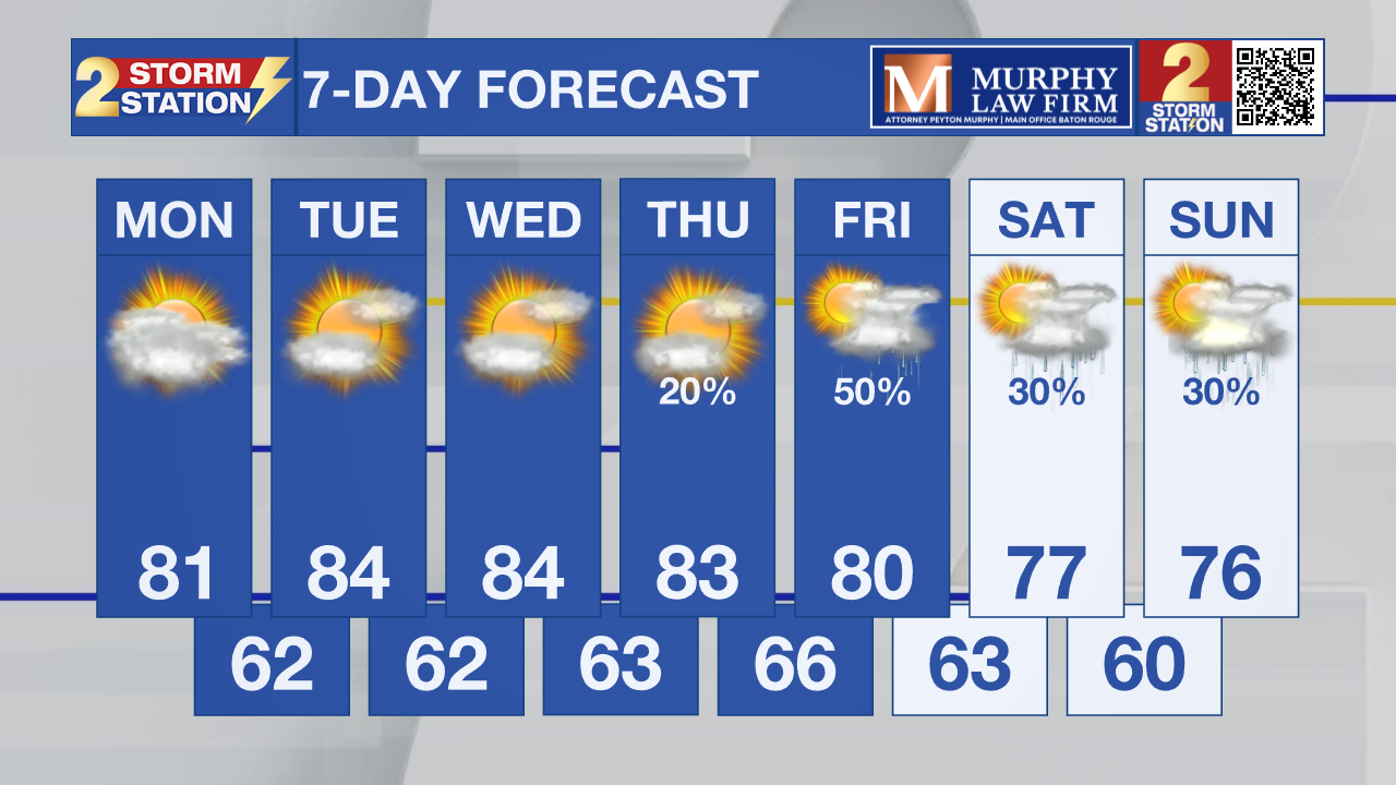
Temperatures continue warming, peaking on Wednesday when we could reach the mid-80s, just shy of records. Humidity will increase slightly, and early-morning fog will remain possible each day.
What to watch out for: A stronger trough digging into the Desert Southwest later this week will begin pushing east, eventually increasing rain chances over Louisiana. Rain chances will climb by Friday, but the timing and strength remain somewhat uncertain. A low-end severe threat may materialize, depending on surface low placement and the degree of instability.
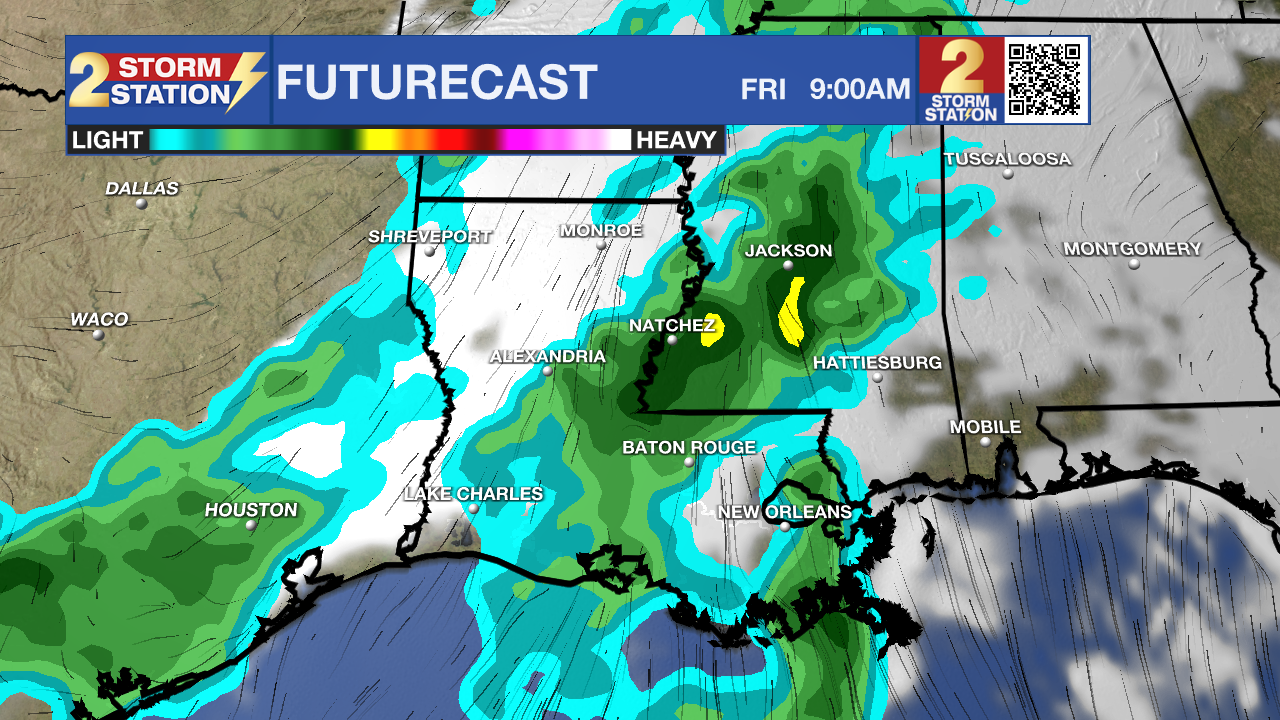
Guidance still varies widely, so confidence remains moderate-to-low on severe potential but higher on the arrival of rain sometime between Thursday night and Friday.
Tropics: No tropical development is expected in the Gulf, Caribbean, or Atlantic over the next 7 days.
Get the latest 7-day forecast and real-time weather updates HERE.
Watch live news HERE.
– Dave
The Storm Station is here for you, on every platform. Your weather updates can be found on News 2, wbrz.com, and the WBRZ WX App on your Apple or Android device. Follow WBRZ Weather on Facebook and X for even more weather updates while you are on the go.
More News
