

Latest Weather Blog
Hurricane Season 2026: NHC forecasts to feature smaller cone, display more alerts
As the 2026 hurricane season approaches, coastal communities will notice significant changes to the maps and tools they rely on during a tropical weather system. The National Hurricane Center (NHC) is rolling out several updates designed to provide more accurate and easier-to-understand forecast information.
CHANGES TO THE CONE
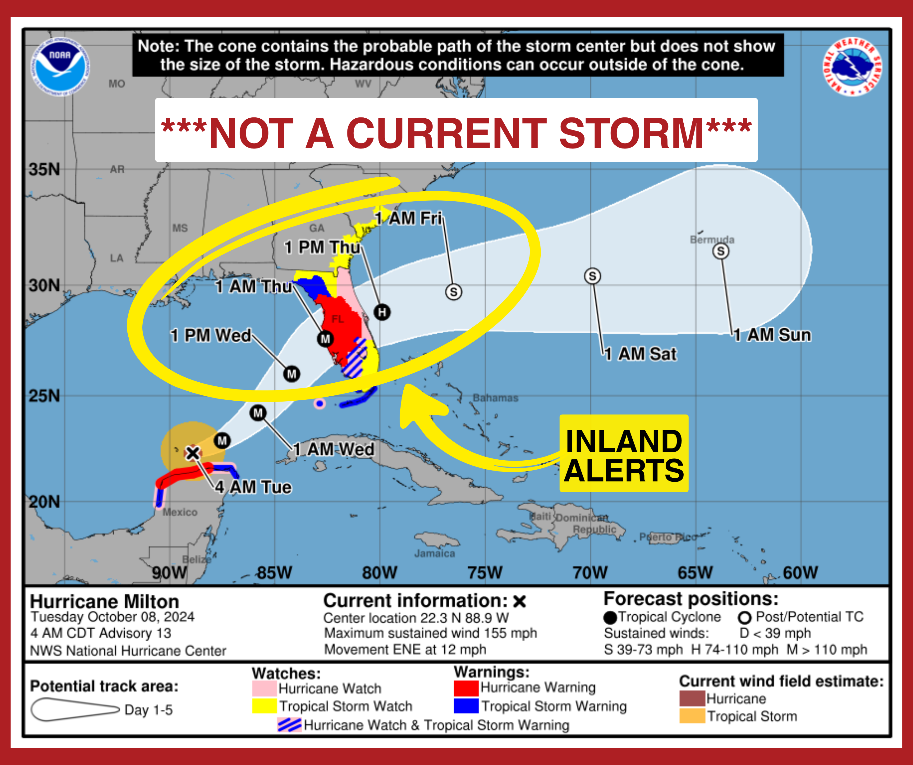
Perhaps the most recognizable graphic in weather, known as the “cone of uncertainty”, is getting a permanent makeover. Starting this year, the cone will now include color-coded watches and warnings for inland areas, not just the coastline. For years, the cone only showed alerts for the immediate beach and bay areas. If you lived in Baton Rouge, Denham Springs, or Gonzales, you often had to look at a separate map to see if your parish was under a Hurricane Warning or a Tropical Storm Warning. Now, those alerts will be layered directly onto the cone graphic from NHC.
Trending News
This change is meant as a reminder that a tropical system isn't just a coastal event. Think of the cone like a flashlight beam; the center of the storm is expected to stay within that beam, but the "light" (the wind and rain) often spills out much further than the beam itself. By showing inland warnings, the NHC wants to make it clear that dangerous winds can travel far from the center of the storm.
With each passing season, the NHC seeks to capitalize on improved weather forecasting and computer modeling by gradually shrinking the cone. For 2026, it will be about 4% to 8% smaller than it was last year. Cone changes are determined by how well forecasts performed over the last five years. Because technology and tracking have improved, the margin of error has decreased. A smaller cone means forecasters are more confident in the storm’s path, though occasionally, a storm may still venture outside of the cone.
CHANGES TO TROPICAL WEATHER OUTLOOKS
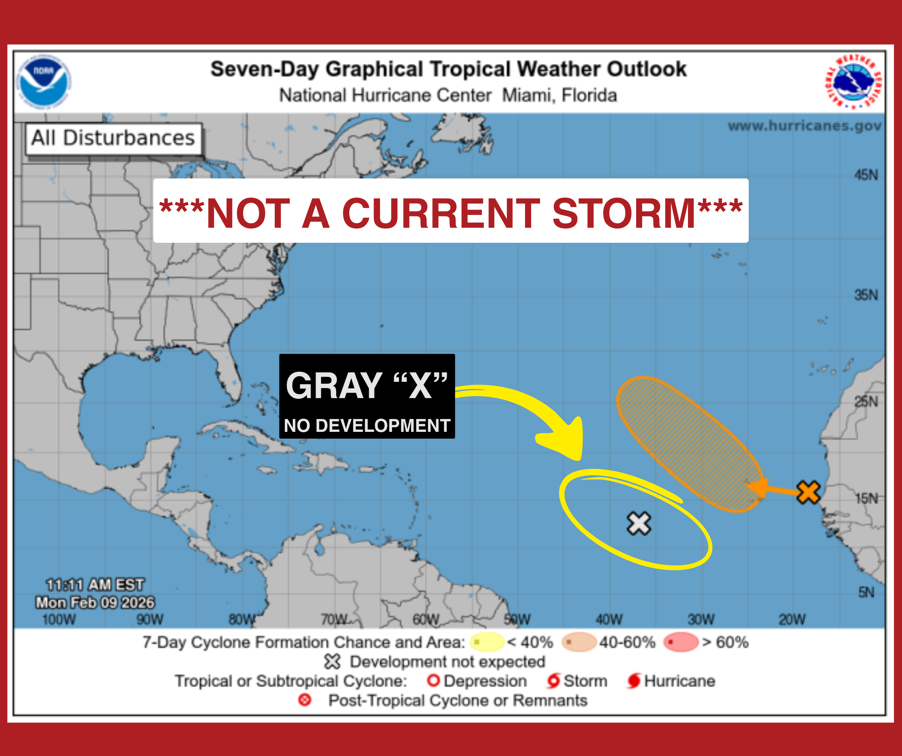
When you check the Tropical Weather Outlook, the map that shows "X" marks over the oceans where storms might form, you might see a new colored “X” that will be gray. Previously, any system with a low, 0 – 30%, chance of developing had an “X” marked in yellow. Starting this year, if a system has a zero percent chance of becoming a tropical depression or storm, it will have an “X” colored in gray. NHC still wants to highlight these systems because they could have the potential to cause heavy rain. However, the gray “X” will provide clarity that the systems will not also become a wind or storm surge threat.
MOBILE-FRIENDLY UPDATES
Recognizing that most people check the weather on their smartphones, the NHC is launching a redesigned, mobile-friendly front page for its website, hurricanes.gov. The new layout is designed to load faster and be easier to navigate on smaller screens during power outages or evacuations.
AN “EXPERIMENTAL” ELLIPSE
In addition to the official changes, the NHC will be testing a new "experimental" cone in 2026. Instead of using circles to build the cone, they will use "ellipses" (oval shapes).
This is a technical change to better account for "along-track" and "cross-track" errors. In simpler terms, it will help NHC forecasts better show if a storm is likely to be fast or slow, rather than just whether it will turn left or right. This experimental version will also cover 90% of the likely path, providing a much wider guardrail than the standard 67% cone.
REMINDER ABOUT POTENTIAL TROPICAL CYCLONES
Recently, NHC began designating Potential Tropical Cyclones (PTCs) to give people more preparation time for developing systems that haven’t technically reached storm or hurricane status. Before this, NHC could not issue alerts for undeveloped systems. Forecasters can now issue official advisories for a PTC up to 72 hours before it arrives. The change gives emergency officials and residents extra notice when there is high confidence that a system will bring dangerous winds or storm surge to the coast.
The 2026 Atlantic Hurricane Season officially begins June 1. The Storm Station is here for you, on every platform. Your tropical weather updates can be found on News 2, wbrz.com, and the WBRZ WX App on your Apple or Android device. Follow WBRZ Weather on Facebook and X for even more weather updates while you are on the go.
More News
