

Latest Weather Blog
Friday PM Forecast: stifling game in Death Valley, eyes on tropics next week
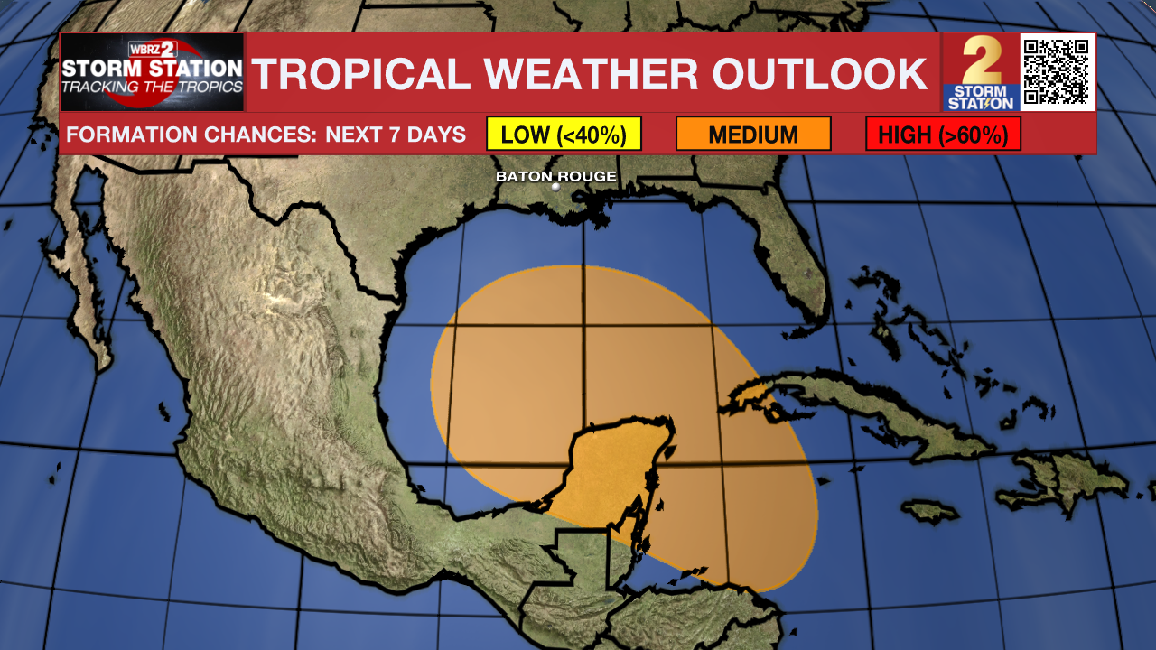
The big story over the weekend will be unseasonably hot temperatures leading into astronomical fall. There is no new news on an area being monitored for development in the Gulf of Mexico late next week. In addition to an update on the tropics (below), Storm Station Meteorologists have addressed the very latest here and here.
Tonight & Tomorrow: The overnight period will be mostly clear and muggy with low temperatures in the low to mid 70s. Saturday will be mostly sunny, warm and humid with high temperatures in the mid 90s. According to the LSU Kickoff Weather Index, a feels-like temperature near 100 degrees at game time will make this one of the top three hottest on record in Tiger Stadium. The last game this hot, and likely the hottest on record, came against Tennessee in 2005 as the teams kicked off to a heat index of 103 degrees.
Up Next: Sunday through Tuesday will feature little change for the beginnings of the new season. Days will feature a mix of sun and clouds with highs in the low to mid 90s and feels-like temperatures near 100 degrees. Nights will be muggy and uncomfortable with lows in the low 70s.
The middle and end of next week will depend on a multitude of variables. The two key features will be an approaching cold front to the north and a tropical disturbance to the south. The rather low confidence forecast at this time calls for a status quo of temperatures through Wednesday with perhaps some added moisture for showers and a slight downturn in temperatures by the end of next week. Expect some changes to the forecast and stick with the Storm Station for those updates.
Timeline of What 2 Expect:
- Late Weekend – upper air currents that will affect front, tropical steering will become more clear
- Middle of Next Week – (possible) development of tropical system will begin
- Next Weekend – (possible) tropical system impacts portions of the Gulf Coast
Trending News
Get the latest 7-day forecast and real time weather updates HERE.
Watch live news HERE.
The Tropics: A broad area of low pressure could form by the early to middle part of next week over the northwestern Caribbean Sea. Thereafter, gradual development of this system is possible, and a tropical depression could form as the system moves slowly to the north or northwest over the northwestern Caribbean Sea and into the southern Gulf of Mexico through the end of next week.
Showers and thunderstorms have been displaced farther away from the center of an area of low pressure (the remnants of Gordon) located over a thousand miles southwest of the Azores due to strong upper-level winds. Significant development of this system is not expected while it meanders over the central subtropical Atlantic during the next couple of days.
An area of low pressure located about 650 miles northeast of the northern Leeward Islands is producing disorganized showers and a few thunderstorms. Environmental conditions do not appear conducive for significant development of this system during the next couple of days while it drifts northwestward at about 5 mph over the central or western subtropical Atlantic.
– Josh
The Storm Station is here for you, on every platform. Your weather updates can be found on News 2, wbrz.com, and the WBRZ WX App on your Apple or Android device. Follow WBRZ Weather on Facebook and Twitter for even more weather updates while you are on the go.
More News
