

Latest Weather Blog
Friday PM Forecast: dodging a few showers this weekend, no washouts expected
As we head into the first weekend of October, the Baton Rouge Area will have a shot at some showers and thunderstorms, all thanks to a weak frontal system sitting just offshore. It isn’t time to cancel weekend plans, though, because most stay dry on Saturday, and even Sunday doesn’t look like a washout.
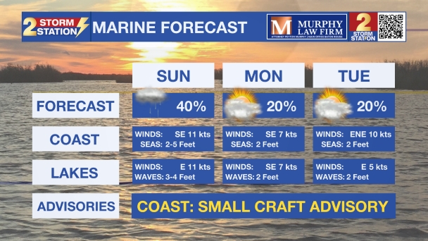
Through the weekend, winds will be noticeable at times with breezes of 10-15mph and higher near the lakes and coast. The persistent winds could lead to some minor coastal flooding and will kick up a considerable chop for small marine craft.
-The Weekend: chances for showers move inland by Sunday, no washouts
-Early Next Week: spotty showers around, especially during the afternoon and sticky
Trending News
-Late Next Week: trending drier
Tonight & Tomorrow: A mainly clear night is ahead. Lows will be seasonably mild in the mid to upper 60s. Saturday looks fairly quiet overall with a mix of sun and clouds. Highs will be comfortably warm in the upper 80s. Rain coverage is expected to be around 20% or less, with any passing showers most likely hugging the coast.
Looking Ahead: Of the two weekend days, Sunday brings the better shot at showers and thunderstorms. Rain coverage will increase to about 50% with scattered activity spreading northwest from the coast and the New Orleans Metro. Know that your chance of measuring rain will decrease the farther you are from the Gulf. If you have outdoor plans around the Baton Rouge Metro or points north, it does not appear there is reason to cancel; you just may need an indoor break option at times. Extra cloud cover will also keep temperatures cooler, with highs only in the low to mid-80s.
As we move into next week, isolated showers and storms will linger on Monday and possibly Tuesday, but we’ll be on a warming trend. Highs will climb into the upper 80s with a muggier feel, and heat index values could push into the upper 90s during the afternoons. By late week, confidence drops in the exact weather pattern, but overall, it doesn’t look too far from average for early October in terms of temperatures and drier conditions.
The Tropics: A weak area of low pressure near the central and northwestern Bahamas is producing disorganized showers. It's expected to drift west-northwest toward southern Florida over the next couple of days. While strong upper-level winds should prevent significant development, the system will still cause heavy rainfall and possible flooding across parts of Florida and the Bahamas through the weekend.
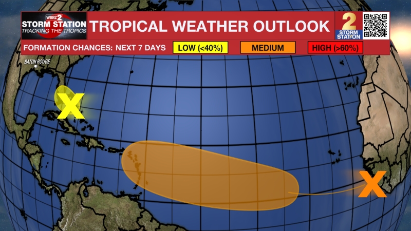
Another tropical wave has recently moved off the coast of Africa. This wave is forecast to interact with another disturbance and then move west. Conditions are expected to become favorable for slow development in a few days, and a tropical depression could form near or east of the Lesser Antilles by the end of next week.
Get the latest 7-day forecast and real-time weather updates HERE.
Watch live news HERE.
– Josh
The Storm Station is here for you, on every platform. Your weather updates can be found on News 2, wbrz.com, and the WBRZ WX App on your Apple or Android device. Follow WBRZ Weather on Facebook and X for even more weather updates while you are on the go.
More News
