

Latest Weather Blog
Friday AM Forecast: Super fog possible in some areas, Warm afternoons continue
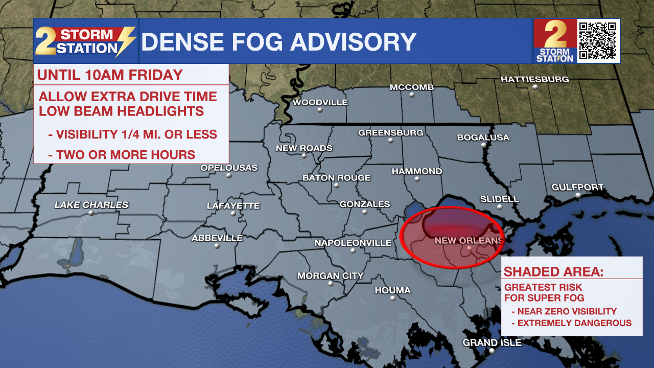
Those traveling around southern Louisiana any morning today through Sunday will need to pay close attention to the forecast and driving conditions. With two on-going marsh fires Southwest of New Orleans, super fog may form in that region. While not a threat in the Capital City, dense fog will still be possible and could limit visibilities to 0.25 of a mile or less at times.
A *DENSE FOG ADVISORY* is in effect through 10 am Friday. Fog may cause visibility of one-quarter mile or less and could make driving conditions hazardous. If driving, slow down, use your low-beam headlights, and leave plenty of distance ahead of you.
A marsh fire burning southwest of New Orleans could help to thicken fog near the Crescent this morning. The mix of smoke and natural fog would create what is known as super fog, and could result in extremely low visibilities and dangerous driving—particularly in St. John, Jefferson and Orleans Parishes. Those commuting to New Orleans for work or Super Bowl festivities should be advised.
Today & Tonight: Besides the fog, Friday morning will again be mild with temperatures in the 60s. By lunchtime, any remaining fog will have burned off and skies will begin to clear. This afternoon will be mostly sunny with highs challenging records again, in the low 80s. Expect another night with the potential for dense fog development and temperatures in the 60s.
Up Next: Fog will be the main concern each morning over the weekend as well. After any reduced visibility near daybreak, both afternoons will feature mostly sunny skies. Temperatures will stay around 15 degrees above average for this time of year, in the middle 80s Sunday and Afternoon with mild overnight lows in the middle 60s.
A front will approach the region slowly by Monday before moving into the Capital Area and stalling north of the I-10/12 corridor on Tuesday. After Monday, an unsettled pattern will take over southern Louisiana as several disturbances pass through. This could result in many rounds of showers and thunderstorms with rainfall amounts expected between 1-3". Heavy rain could become an issue, especially if it falls at a rate of more than an inch per hour. Since vegetation is dormant, there could be more runoff, increasing the risk of localized flooding. Temperatures will stay mild, with lows in the lower 60s and highs in the mid to upper 70s.
Trending News
Get the latest 7-day forecast and real-time weather updates HERE.
Watch live news HERE.
– Emma Kate C.
The Storm Station is here for you, on every platform. Your weather updates can be found on News 2, wbrz.com, and the WBRZ WX App on your Apple or Android device. Follow WBRZ Weather on Facebook and X for even more weather updates while you are on the go.
More News
