

Latest Weather Blog
Friday AM forecast: Mild days before temperatures tumble
After a chilly stretch earlier this week, temperatures continue their rapid rebound today as a warm, moist onshore flow pushes highs back into the lower 70s—well above normal for mid-December. Fog could become an issue late tonight as moisture deepens. Weekend rain chances return late Saturday and Sunday ahead of a sharp cold plunge to start next week.
.png)
Today and tonight: Today brings a notable warmup thanks to a persistent onshore flow. Highs this afternoon will reach the lower 70s across the Baton Rouge area, running around 8–10 degrees above climatological averages. Skies stay partly to mostly cloudy, but the day remains generally dry. Rain chances will stay around 20%.

Use the slider to advance through the next 24 hours of Futurecast
Trending News
Tonight, moisture pools closer to the surface, and several short-range models highlight increasing fog potential. Conditions appear favorable for patchy to possibly dense fog after midnight, especially near rivers, lakes, and low-lying areas. Temperatures remain mild, mainly in the mid-50s.
Up Next: A quick-moving upper disturbance arrives Saturday, giving parts of the region the best chance at showers, with lower probabilities as you move south toward Baton Rouge. Most areas will stay dry or only see brief, light rain.
A stronger system approaches late Saturday night into early Sunday as a deep trough slides across the Midwest. A cold front sweeps into the Gulf before sunrise Sunday, bringing moderate rain chances, highest north of Baton Rouge. Thunder is unlikely as instability is lacking.
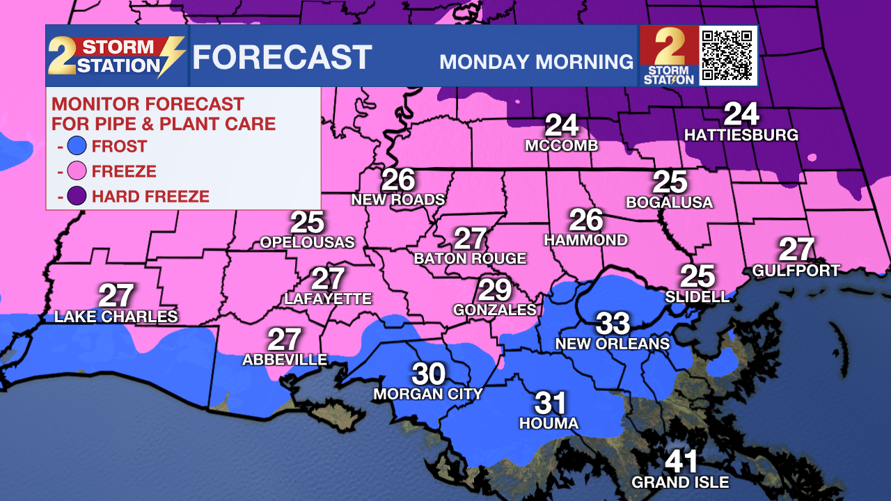
Behind the front, temperatures tumble. Sunday night into Monday morning brings the coldest air of the season so far. Lows will drop into the 20s as far south as Baton Rouge. Wind chills will make it feel even colder.
What to look out for:
Fog potential tonight will be the first impact to monitor, as increasing Gulf moisture meets cooling evening temperatures. Weekend rain chances stay modest but increase early Sunday before the front moves through. The biggest concern comes Monday morning when a hard freeze is possible north of Baton Rouge and a light freeze is likely in several outlying parishes.
Get the latest 7-day forecast and real-time weather updates HERE.
Watch live news HERE.
– Dave
The Storm Station is here for you, on every platform. Your weather updates can be found on News 2, wbrz.com, and the WBRZ WX App on your Apple or Android device. Follow WBRZ Weather on Facebook and X for even more weather updates while you are on the go.
More News
