

Latest Weather Blog
Friday AM Forecast: Hottest weekend of the year ahead, staying mainly dry
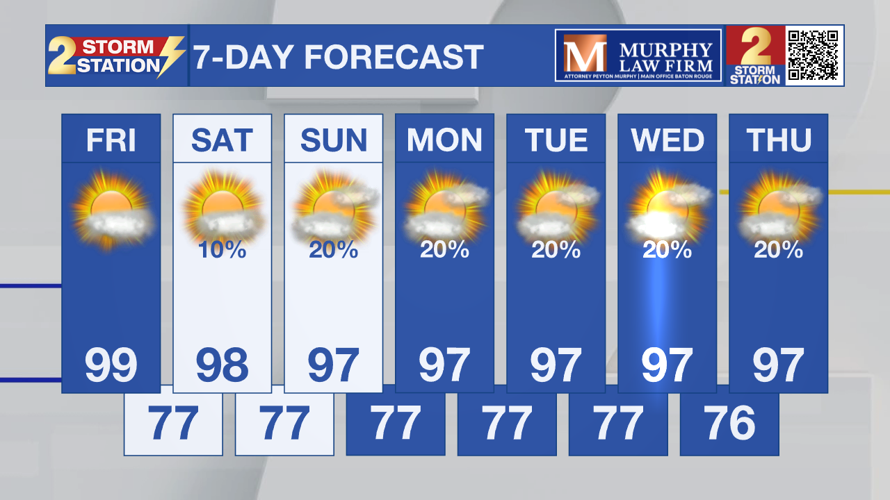
Forecasted highs are in the upper 90s through this weekend, with some locations possibly reaching the triple digits. This will make it the hottest weekend of the year so far! Not much relief will come from the skies, as conditions will stay mainly dry.

Today & Tonight: So far this year, high temperatures have reached 98° on several occasions, but nothing higher. That could change today, with forecasted high temperatures near 99°. It's not out of the question that some locations could see the triple digits. A Heat Advisory has been issued, which is no surprise given the expected conditions. Peak heat index values will reach near 108°, so make sure to slow down if outside and drink plenty of water. No rain will occur so everyone will feel the heat. Overnight, skies will be mainly clear with lows in the upper 70s.
Up Next: Hot and mainly dry conditions will persist for the foreseeable future. Highs will stay in the upper 90s through the end of next week. While a stray shower is possible, most of us will stay completely dry. Humidity will uptick a bit late weekend into early next week, causing even higher heat index values. Day after day of continued heat will make the threat of heat illness even higher, so make sure to listen to your body and hydrate plenty.
Given how dry it has been, the latest drought monitor reveals abnormally dry conditions around the area. The continued dry conditions are likely to make this worse, and we could see a rapid onset of drought conditions by next week. This is known as a flash drought.
Trending News
Get the latest 7-day forecast and real-time weather updates HERE.
Watch live news HERE.
The Tropics:
Central Tropical Atlantic:
Showers and thunderstorms associated with a tropical wave located about 650 miles east of the Lesser Antilles have continued to become less organized. This system is moving into a region of increasing upper-level winds and dry air, and the possibility of development is decreasing. Regardless of development, interests in the Lesser Antilles should continue to monitor the progress of this system since gusty winds and areas of heavy rain are possible across these islands Friday night and Saturday.
Eastern Tropical Atlantic:
A tropical wave located several hundred miles southwest of the Cabo Verde Islands is producing disorganized showers and thunderstorms. Environmental conditions are forecast to be generally conducive for gradual development, and a tropical depression could form late this week or this weekend while the wave moves westward or west-northwestward across the eastern and central tropical Atlantic.

– Balin
The Storm Station is here for you, on every platform. Your weather updates can be found on News 2, wbrz.com, and the WBRZ WX App on your Apple or Android device. Follow WBRZ Weather on Facebook and X for even more weather updates while you are on the go.
More News

